This program produces a PVL formatted file that contains the
mapping group keywords required to transform an image to a
map projection.
Required Input
- Map File Template output filename
- Projection name
- Additional parameters required for specific projections
- Input list if CALC option will be used
Output
A PVL formatted Map File Template containing mapping group keywords
for the selected projection. The '.map' extension is appended to the output
file automatically, if the file extension is not provided by the user. The
output file may contain all or some of the map specifications listed below:
- User-preferred projection type (required)
- Other keywords required for specific projections
- Target body radii
- Latitude/longitude coverage or ground range
- Pixel resolution
- Latitude and longitude definitions
- Distance from center of target
- Standard parallels
Map File Template Creation
To convert a raw instrument/camera cube (Level1) to a map projected
image (Level2) the user must (1) create a custom PVL formatted
text file, (2) use this maptemplate application to produce one, or (3) use
the automated, projection-specific Map File Template in $ISISROOT/templates/appdata/maps.
Whichever method that you choose, the Map File Template should contain the necessary
keywords to project an image.
Map File Template Creation Choices:
-
PVL formatted text file: you must make a list of parameters
based on the projection you wish to use, and input the appropriate values
for each. The following example is a custom Map File Template for defining
the projection of an image of Mars to the sinusoidal projection:
 Group = Mapping
 TargetName         = Mars
 EquatorialRadius   = 3396190.0 <meters>
 PolarRadius        = 3376200.0 <meters>
 LatitudeType       = Planetocentric
 LongitudeDirection = PositiveEast
 LongitudeDomain    = 360

 ProjectionName     = Sinusoidal
 CenterLongitude    = 227.95679808356

 MinimumLatitude    = 10.766902750622
 MaximumLatitude    = 34.44419678224
 MinimumLongitude   = 219.7240455337
 MaximumLongitude   = 236.18955063342

 PixelResolution    = 426.87763879023 <meters/pixel>
 End_Group
The example above contains both required and optional keywords.
-
The maptemplate application: maptemplate will prompt you for
all the necessary parameters to project your image. However, the planar and
ring cylindrical projections are excluded from use in the application, because
it requires keywords that are not defined in the program.
-
Templates in $ISISROOT/templates/appdata/maps: the template contains all the
parameters necessary to project an image, and only the Projection name is
"uncommented" in the file. This is because some projections only require
that you enter a projection name, and the default values are computed for
the remaining keywords. In such cases where the default value cannot be
calculated using the camera model or ISIS system default, you must
"uncomment" the appropriate line(s) of the template and set the values.
See example below:
Group = Mapping
  ProjectionName  = LambertConformal
# CenterLatitude  = 0.0 <degrees>
# CenterLongitude = 0.0 <degrees>
# Earth (ographic)
# FirstStandardParallel  = 33.0 <degrees>
# SecondStandardParallel = 45.0 <degrees>

# Mars (ographic)
# FirstStandardParallel  = 35.83 <degrees>  *Remove # to uncomment and change 35.83 to your value
# SecondStandardParallel = 59.17 <degrees>  *Remove # to uncomment and change 59.17 to your value
  End_Group
Identifying Required Parameters:
The following is a list of projections and keywords that are required. When
a keyword is missing, and you try to project an image using projection
software like cam2map, an error will occur. Below is a list of
projections and the keywords that must be in the Map File Template:
How the defaults are set for Mapping Group keywords:
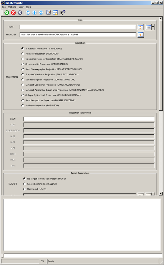
Maptemplate GUI Interface
Radio buttons in the GUI are used to select options. Once an option is
selected, the required parameters pertinent to that option become activated;
therefore the user should complete the highlighted fields in the different
parameter sections. Use the right scroll bar on the right side of the GUI
to see all the available options.
The
button is used for RNGOPT and RESOPT options. If the button is clicked,
the range will be calculated and automatically entered in the GUI
fields with the appropriate values. For SELECT, the
button is used to select a Map File Template, the
button is use to view the contents of
the selected file at the bottom of the GUI, and the "Down Arrow" button is
used to load the contents of the selected file into the appropriate GUI fields.
When the target name is set and no other value is specified, the
button next to EQRADIUS is used to display the system
radii in the log area.
Parameter Setting Action
Other Uses for Your Created Map file: The output Map File can be used
in applications that use projections, such as cam2map, map2map,
mapsize, skymap, and more.
See
"Learning About Map Projections" to learn more about mapping keywords.
| Elizabeth Ribelin | 2005-09-13 |
Original Version
|
| Elizabeth Miller | 2005-11-17 |
Added .map extension to TO file and fixed bug with spaces in the projection name
|
| Elizabeth Miller | 2006-05-18 |
Deprecated CubeProjection and ProjectionManager to ProjectionFactory
|
| Robert Sucharski | 2006-06-02 |
Redid GUI, added code to calculate ground range and resolution using FROMLIST, and
added Help buttons
|
| Steven Lambright | 2008-04-23 |
Added oblique cylindrical projection
|
| Steven Lambright | 2009-02-05 |
Fixed a problem that occurred when using "TARGOPT=USER", "RNGOPT=CALC" and not entering "EQRADIUS" or "POLRADIUS"
|
| Steven Lambright | 2011-12-19 |
Updated documentation as per Ella Lee's recommendations in preparation for
the January 2012 release.
|
| Kimberly Oyama | 2013-04-03 |
Added support for Point Perspective Projection. Fixes #212.
|
| Debbie A. Cook | 2013-04-16 |
Changed to use TProjection instead of Projection. References #775
|
| Ella Mae Lee | 2013-11-25 |
Added LambertAzimuthalEqualArea and Robinson projections. Updated the user
documentation, fixes #845.
|
| Ella Mae Lee | 2013-12-12 |
Backward compatability issue due to parameter name change: TARGOPT options
changed from SYSTEM to SELECT, IMAGE to NONE, and TARGDEF to FILE. The
description was modified to describe the behavior when selected, fixes #845.
|
| Jeannie Backer | 2016-04-22 |
Added error message to alert to the user when the program fails to find TargetRadii.
Added errors appTest. References #3892
|