|
| | Projection (Pvl &label) |
| | Constructs an empty Projection object.
|
| |
| virtual | ~Projection () |
| | Destroys the Projection object.
|
| |
| virtual bool | operator== (const Projection &proj) |
| | This method determines whether two map projection objects are equal by comparing the resolution, and projection name.
|
| |
| bool | operator!= (const Projection &proj) |
| | This method determines whether two map projection objects are not equal.
|
| |
| void | setProjectionType (const ProjectionType ptype) |
| | Sets the projection subclass type.
|
| |
| ProjectionType | projectionType () const |
| | Returns an enum value for the projection type.
|
| |
| bool | IsSky () const |
| | Returns true if projection is sky and false if it is land.
|
| |
| virtual QString | Name () const =0 |
| | This method returns the name of the map projection.
|
| |
| virtual double | LocalRadius () const =0 |
| |
| virtual QString | Version () const =0 |
| | This method returns the Version of the map projection.
|
| |
| virtual bool | IsEquatorialCylindrical () |
| | This method returns true if the projection is equatorial cylindrical.
|
| |
| virtual bool | HasGroundRange () const |
| | This indicates if the longitude direction type is positive west (as opposed to postive east).
|
| |
| double | Rotation () const |
| | Returns the value of the Rotation keyword from the mapping group.
|
| |
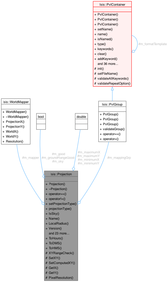
| void | SetWorldMapper (WorldMapper *mapper) |
| | If desired the programmer can use this method to set a world mapper to be used in the SetWorld, WorldX, and WorldY methods.
|
| |
| virtual bool | SetGround (const double lat, const double lon)=0 |
| |
| virtual bool | SetCoordinate (const double x, const double y)=0 |
| |
| bool | IsGood () const |
| | This indicates if the last invocation of SetGround, SetCoordinate, SetUniversalGround, or SetWorld was with successful or not.
|
| |
| double | XCoord () const |
| | This returns the projection X provided SetGround, SetCoordinate, SetUniversalGround, or SetWorld returned with success.
|
| |
| double | YCoord () const |
| | This returns the projection Y provided SetGround, SetCoordinate, SetUniversalGround, or SetWorld returned with success.
|
| |
| virtual bool | SetUniversalGround (const double coord1, const double coord2) |
| | This method is used to set the lat/lon or radius/azimuth (i.e.
|
| |
| virtual bool | SetUnboundUniversalGround (const double coord1, const double coord2) |
| | This method is used to set the lat/lon or radius/azimuth (i.e.
|
| |
| virtual bool | SetWorld (const double x, const double y) |
| | This method is used to set a world coordinate.
|
| |
| virtual double | WorldX () const |
| | This returns the world X coordinate provided SetGround, SetCoordinate, SetUniversalGround, or SetWorld returned with success.
|
| |
| virtual double | WorldY () const |
| | This returns the world Y coordinate provided SetGround, SetCoordinate, SetUniversalGround, or SetWorld returned with success.
|
| |
| double | ToWorldX (const double projectionX) const |
| | This method converts a projection x value to a world x value.
|
| |
| double | ToWorldY (const double projectionY) const |
| | This method converts a projection y value to a world y value.
|
| |
| double | ToProjectionX (const double worldX) const |
| | This method converts a world x value to a projection x value.
|
| |
| double | ToProjectionY (const double worldY) const |
| | This method converts a world y value to a projection y value.
|
| |
| double | Resolution () const |
| | This method returns the resolution for mapping world coordinates into projection coordinates.
|
| |
| virtual double | Scale () const =0 |
| |
| virtual bool | XYRange (double &minX, double &maxX, double &minY, double &maxY)=0 |
| |
| void | SetUpperLeftCorner (const Displacement &x, const Displacement &y) |
| | This method is used to find the XY range for oblique aspect projections (non-polar projections) by "walking" around each of the min/max lat/lon.
|
| |
| virtual PvlGroup | Mapping ()=0 |
| |
|
| WorldMapper * | m_mapper |
| | This points to a mapper passed into the SetWorldMapper method.
|
| |
| bool | m_good |
| | Indicates if the contents of m_x, m_y, m_latitude, and m_longitude are valid.
|
| |
| bool | m_sky |
| | Indicates whether projection is sky or land.
|
| |
| bool | m_groundRangeGood |
| | Indicates if the ground range (min/max lat/lons) were read from the labels.
|
| |
| double | m_minimumX |
| | The data elements m_minimumX, m_minimumY, m_maximumX, and m_maximumY are convience data elements when you write the XYRange virtual function.
|
| |
| double | m_maximumX |
| | See minimumX description.
|
| |
| double | m_minimumY |
| | See minimumX description.
|
| |
| double | m_maximumY |
| | See minimumX description.
|
| |
| PvlGroup | m_mappingGrp |
| | Mapping group that created this projection.
|
| |
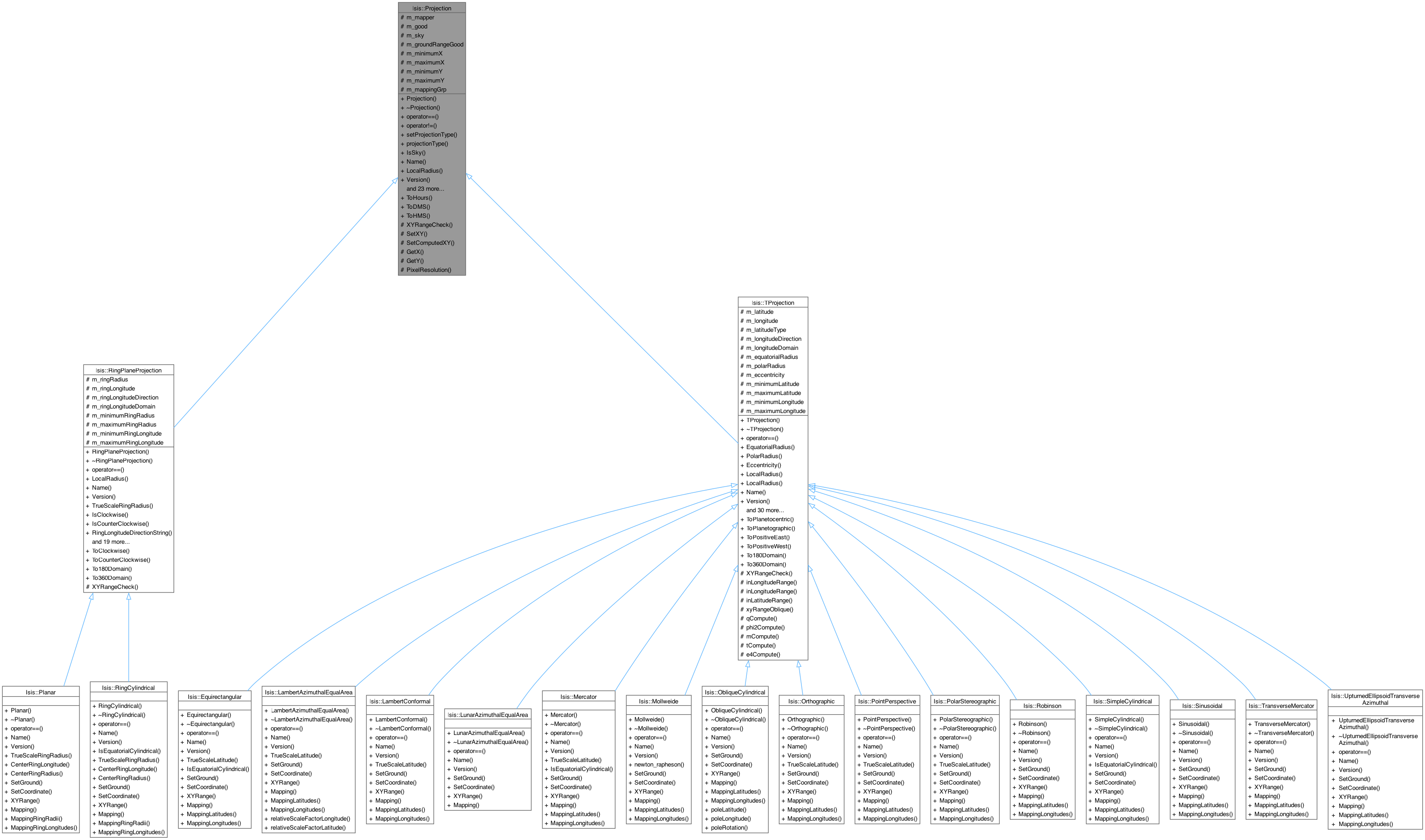
Base class for Map Projections.
This is a virtual base class for map projections. It must be used to create specific map projection classes such as Sinusoidal, Mercator, etc. The foundation of this class is the ability to convert ground coordinates (latitude and longitude) into projection coordinates (x and y) and vice versa. Options exist to allow conversion to and from programmer specified world coordinates. The world coordinates can be cube pixels, paper units in millimeters, or any other unit the program may need. Generally, you should never directly instantiate this class.
Here is an example of how to use Projection
lab.Read("projection.map");
static Isis::Projection * Create(Isis::Pvl &label, bool allowDefaults=false)
This method returns a pointer to a Projection object.
Definition ProjectionFactory.cpp:51
Projection(Pvl &label)
Constructs an empty Projection object.
Definition Projection.cpp:91
Container for cube-like labels.
Definition Pvl.h:119
If you would like to see Projection being used in implementation, see mappos.cpp
- Author
- 2003-01-29 Jeff Anderson
| Isis::Projection::Projection |
( |
Pvl & | label | ) |
|
Constructs an empty Projection object.
- Parameters
-
| label | A PVL object containing map projection labels. These labels are fully described in the Isis Map Projection Users Guide. A brief example follows:
EquatorialRadius = 3396190.0
PolarRadius = 3376200.0
LongitudeDirection = PositiveEast
LongitudeDomain = 360
LatitudeType = Planetographic
MinimumLatitude = 10.8920539924144
MaximumLatitude = 34.7603960060206
MinimumLongitude = 219.72432466275
MaximumLongitude = 236.186050244411
CenterLongitude = 220.0
EndGroup
End
double PixelResolution() const Returns the pixel resolution value from the PVL mapping group in meters/pixel. Definition Projection.cpp:840 virtual PvlGroup Mapping()=0 Simple Cylindrical Map Projection. Definition SimpleCylindrical.h:69 |
- Exceptions
-
| IException::Unknown | - "Projection failed. No target radii
available through keywords [EquatorialRadius and
PolarRadius] or [TargetName]." |
| IException::Unknown | - "Projection failed. Invalid value
for keyword [EquatorialRadius]. It must be greater than
zero." |
| IException::Unknown | - "Projection failed. Invalid value
for keyword [PolarRadius]. It must be greater than zero." |
| IException::Unknown | - "Projection failed. Invalid value
for keyword [LatitudeType] must be [Planetographic or
Planetocentric]" |
| IException::Unknown | - "Projection failed. Invalid value
for keyword [LongitudeDirection] must be [PositiveWest or
PositiveEast]" |
| IException::Unknown | - "Projection failed. Invalid value
for keyword [LongitudeDomain] must be [180 or 360]" |
| IException::Unknown | - "Projection failed.
[MinimumLatitude] is outside the range of [-90:90]" |
| IException::Unknown | - "Projection failed.
[MaximumLatitude] is outside the range of [-90:90]" |
| IException::Unknown | - "Projection failed.
[MinimumLatitude,MaximumLatitude] are not properly ordered" |
| IException::Unknown | - "Projection failed.
[MinimumLongitude,MaximumLongitude] are not properly ordered" |
| IException::Unknown | - "Projection failed. Invalid keyword
value(s). [EquatorialRadius] must be greater than or equal to
[PolarRadius]" |
| IException::Unknown | - "Projection failed. Invalid label
group [Mapping]" |
References _FILEINFO_, Isis::PvlObject::findGroup(), m_good, m_mapper, m_mappingGrp, m_maximumX, m_maximumY, m_minimumX, m_minimumY, m_sky, Isis::Null, Isis::PvlObject::Traverse, and Isis::IException::Unknown.
Referenced by operator!=(), operator==(), Isis::RingPlaneProjection::operator==(), Isis::TProjection::operator==(), Isis::RingPlaneProjection::RingPlaneProjection(), and Isis::TProjection::TProjection().
| bool Isis::Projection::HasGroundRange |
( |
| ) |
const |
|
virtual |
This indicates if the longitude direction type is positive west (as opposed to postive east).
The longitude type was obtained from the label during object construction.
- Returns
- bool This indicates if the longitude direction type is positive east (as opposed to postive west). The longitude type was obtained from the label during object construction.
-
bool This method returns the longitude direction as a string. It will return either PositiveEast or PositiveWest.
-
string The longitude direction, "PositiveEast" or "PositiveWest". This indicates if the longitude domain is -180 to 180 (as opposed to 0 to 360). The longitude domain was obtained from the label during object construction.
-
bool This indicates if the longitude domain is 0 to 360 (as opposed to -180 to 180). The longitude domain was obtained from the label during object construction.
-
bool This method converts a longitude into the -180 to 180 domain. It will leave the longitude unchanged if it is already in the domain.
- Parameters
-
| lon | Longitude to convert into the -180 to 180 domain. |
- Exceptions
-
- Returns
- double The longitude, converted to 180 domain. This method converts a longitude into the 0 to 360 domain. It will leave the longitude unchanged if it is already in the domain.
- Parameters
-
| lon | Longitude to convert into the 0 to 360 domain. |
- Returns
- double The longitude, converted to 360 domain. This method returns the longitude domain as a string. It will return either 180 or 360.
-
string The longitude domain, "180" or "360". This indicates that the labels contained minimum and maximum ground coordinatess (e.g., a ground range coverage). If the projection has ground range coverage then the MinimumLatitude, MaximumLatitude, MinimumLongitude, and MaximumLongitude methods or comparable methods for other projection types can be used. The ground range coverage essentially defines the area of user interest.
-
bool
References m_groundRangeGood.
Referenced by Isis::ProjectionFactory::CreateForCube(), Isis::RingPlaneProjection::Mapping(), Isis::TProjection::MappingLatitudes(), Isis::TProjection::MappingLongitudes(), Isis::Planar::MappingRingLongitudes(), Isis::RingCylindrical::MappingRingLongitudes(), Isis::RingPlaneProjection::MappingRingLongitudes(), Isis::Planar::MappingRingRadii(), Isis::RingCylindrical::MappingRingRadii(), Isis::RingPlaneProjection::MappingRingRadii(), Isis::ProjectionFactory::RingsCreateForCube(), and Isis::TProjection::xyRangeOblique().
This method is used to find the XY range for oblique aspect projections (non-polar projections) by "walking" around each of the min/max lat/lon.
- Parameters
-
| minX | Minimum x projection coordinate which covers the latitude longitude range specified in the labels. |
| maxX | Maximum x projection coordinate which covers the latitude longitude range specified in the labels. |
| minY | Minimum y projection coordinate which covers the latitude longitude range specified in the labels. |
| maxY | Maximum y projection coordinate which covers the latitude longitude range specified in the labels. |
- Returns
- bool Indicates whether the method was successful.
- See also
- XYRange()
- Author
- Stephen Lambright This method searches for extreme (min/max/discontinuity) coordinate values along the constBorder line between minBorder and maxBorder (that is, across latitudes/longitudes). This method locates the extrema by utilizing the findExtreme() method until the coordinate values converge. Then, extremeVal parameter is updated with this value before returning.
Discontinuities are stored in m_specialLatCases and m_specialLonCases so they may be checked again later, which creates significantly more accuracy in some cases.
- Parameters
-
| minBorder | Minimum latitude or longitude to search between. |
| maxBorder | Maximum latitude or longitude to search between. |
| extremeVal | The resulting global coordinate value (min or max value for x or y, depending on findMin and searchX) on the constBorder. |
| constBorder | The latitude or longitude that remains constant. The method will step along this border. |
| searchX | Indicates whether the method is searching for a min or max x-coordinate. If false the method searches for min or max y-coordinate. |
| searchLongitude | Indicates whether the method will search along a longitude. If true, constBorder is longitude and all other borders are latitudes. If false, the method searches a latitude (constBorder is a lat, other borders lons). |
| findMin | Indicates whether the method is looking for a minimum coordinate value. If false, the method is looking for a maximum value. |
- Author
- Steven Lambright Searches for extreme (min/max/discontinuity) coordinate values across latitudes/longitudes.
This method looks for these extrema along the constBorder between minBorder and maxBorder by stepping along constBorder (10 times) from the minBorder and maxBorder. Then, the range of this extreme value is recorded in minBorder and maxBorder and the coordinate values corresponding to these new borders are stored in minBorderX, minBorderY, maxBorderX and maxBorderY.
This function should be used by calling it repeatedly until minBorderX and minBorderY do not equal maxBorderX and maxBorderY, respectively. Discontinuities will cause the minBorderX, minBorderY, maxBorderX and maxBorderY to never converge. If minBorderX never comes close to maxBorderX or minBorderY never comes close to maxBorderY, then between minBorder and maxBorder is the value of the most extreme value. In this case, either the smaller or larger of the x or y values found will be correct, depending on the values of findMin and searchX.
- Parameters
-
| minBorder | Minimum latitude or longitude to search between. This value gets updated to a more precise range. |
| maxBorder | Maximum latitude or longitude to search between. This value gets updated to a more precise range. |
| minBorderX | The x-value corresponding to the lower resultant minBorder and the constBorder, which is more accurate when nearly equal to maxBorderX. |
| minBorderY | The y-value corresponding to the lower resultant minBorder and the constBorder, which is more accurate when nearly equal to maxBorderY. |
| maxBorderX | The x-value corresponding to the higher resultant maxBorder and the constBorder, which is more accurate when nearly equal to minBorderX. |
| maxBorderY | The y-value corresponding to the higher resultant maxBorder and the constBorder, which is more accurate when nearly equal to minBorderY. |
| constBorder | The latitude or longitude that remains constant. The method will step along this border. |
| searchX | Indicates whether the method is searching for a min or max x-coordinate. If false the method searches for min or max y-coordinate. |
| searchLongitude | Indicates whether the method will search along a longitude. If true, constBorder is longitude and all other borders are latitudes. If false, the method searches a latitude (constBorder is a lat, other borders lons). |
| findMin | Indicates whether the method is looking for a minimum coordinate value. If false, the method is looking for a maximum value. |
- Author
- Stephen Lambright This function sets the ground for the given border values. It calls the SetGround(lat, lon) method with the appropriate lat/lon values, depending on whether variableIsLat is true.
This method is used by doSearch and findExtreme in order to set the ground correctly each time.
- Parameters
-
| variableBorder | The latitude or longitude that is variable in the search methods. |
| constBorder | The latitude or longitude that is constant in the search methods. |
| variableIsLat | Indicates whether variableBorder is the latittude value and constBorder is the longitude value. If false, variableBorder is the longitude value and constBorder is the latitude value. |
- Author
- Stephen Lambright This method sets the UpperLeftCornerX and UpperLeftCornerY keywords in the projection mapping group, in meters.
- Parameters
-
| x | the upper left corner x value |
| y | the upper left corner y value |
References m_mappingGrp, Isis::Displacement::meters(), Isis::PvlContainer::Replace, and Isis::toString().
Referenced by Isis::ProjectionFactory::CreateForCube(), Isis::ProjectionFactory::CreateForCube(), Isis::ProjectionFactory::CreateFromCube(), Isis::ProjectionFactory::RingsCreateForCube(), Isis::ProjectionFactory::RingsCreateForCube(), Isis::ProjectionFactory::RingsCreateFromCube(), and Isis::ProcessMapMosaic::SetOutputCube().
| bool Isis::Projection::SetWorld |
( |
const double | worldX, |
|
|
const double | worldY ) |
|
virtual |
This method is used to set a world coordinate.
A world coordinate is a different coordinate type that has a one-to-one mapping to the projection coordinate system. For example, mapping pixel samples and lines to projection x's and y's. The Set forces an attempted calculation of the corresponding latitude/longitude position. This may or may not be successful and a status is returned as such. Note that is only applies if the Projection object was given an WorldMapper object during construction. If an WorldMapper was not supplied then SetWorld operates exactly the same as SetCoordinate (impling that world coordinate and projection coordinate are identical).
- Parameters
-
| worldX | World X coordinate in units that are specified by the WorldMapper object (e.g., pixels, millimeters, etc) |
| worldY | World Y coordinate in units that are specified by the WorldMapper object (e.g., pixels, millimeters, etc) |
- Returns
- bool Indicates whether the method was successful.
References m_mapper, and SetCoordinate().
Referenced by Isis::ProcessExport::CreateWorldFile(), Isis::UniversalGroundMap::GroundRange(), Isis::Cube::latLonRange(), Isis::Chip::Load(), Isis::SubArea::UpdateLabel(), and Isis::PolygonTools::XYToLatLon().