|
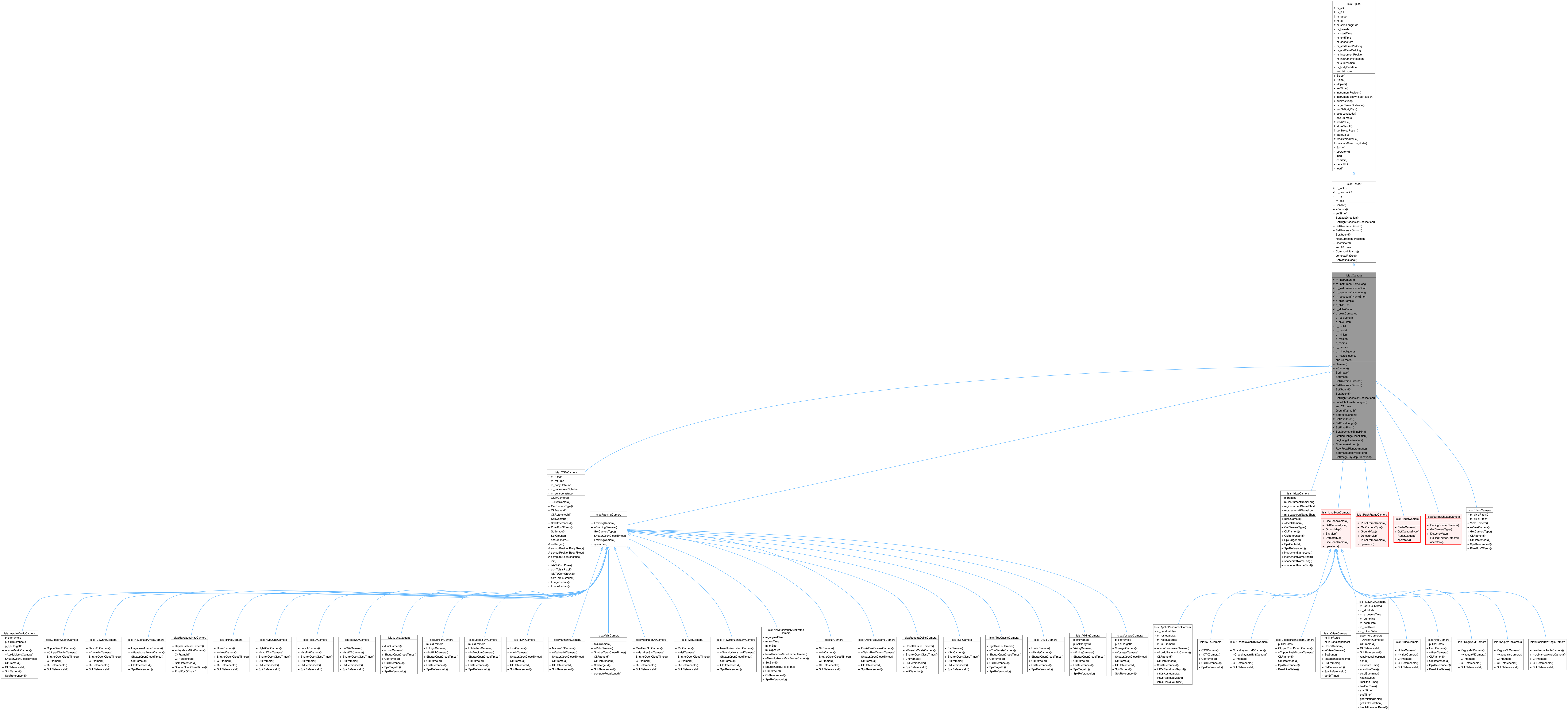
| | Camera (Cube &cube) |
| | Constructs the Camera object.
|
| |
| virtual | ~Camera () |
| | Destroys the Camera Object.
|
| |
| virtual bool | SetImage (const double sample, const double line) |
| | Sets the sample/line values of the image to get the lat/lon values.
|
| |
| virtual bool | SetImage (const double sample, const double line, const double deltaT) |
| | Sets the sample/line values of the image to get the lat/lon values with a time offset of deltaT.
|
| |
| virtual bool | SetUniversalGround (const double latitude, const double longitude) |
| | Sets the lat/lon values to get the sample/line values.
|
| |
| virtual bool | SetUniversalGround (const double latitude, const double longitude, const double radius) |
| | Sets the lat/lon/radius values to get the sample/line values.
|
| |
| virtual bool | SetGround (Latitude latitude, Longitude longitude) |
| | Sets the lat/lon values to get the sample/line values.
|
| |
| virtual bool | SetGround (const SurfacePoint &surfacePt) |
| | Sets the lat/lon/radius values to get the sample/line values.
|
| |
| virtual bool | SetRightAscensionDeclination (const double ra, const double dec) |
| | Sets the right ascension declination.
|
| |
| void | LocalPhotometricAngles (Angle &phase, Angle &incidence, Angle &emission, bool &success) |
| | Calculates LOCAL photometric angles using the DEM (not ellipsoid).
|
| |
| void | Slope (double &slope, bool &success) |
| | Calculates the slope at the current point by computing the angle between the local surface normal and the ellipsoid surface normal.
|
| |
| void | GetLocalNormal (double normal[3]) |
| | This method will find the local normal at the current (sample, line) and set it to the passed in array.
|
| |
| bool | HasProjection () |
| | Checks to see if the camera object has a projection.
|
| |
| virtual bool | IsBandIndependent () |
| | Virtual method that checks if the band is independent.
|
| |
| int | ReferenceBand () const |
| | Returns the reference band.
|
| |
| bool | HasReferenceBand () const |
| | Checks to see if the Camera object has a reference band.
|
| |
| virtual void | SetBand (const int band) |
| | Virtual method that sets the band number.
|
| |
| virtual double | Sample () const |
| | Returns the current sample number.
|
| |
| virtual int | Band () const |
| | Returns the current band.
|
| |
| virtual double | Line () const |
| | Returns the current line number.
|
| |
| bool | GroundRange (double &minlat, double &maxlat, double &minlon, double &maxlon, Pvl &pvl) |
| | Computes the Ground Range.
|
| |
| bool | ringRange (double &minRingRadius, double &maxRingRadius, double &minRingLongitude, double &maxRingLongitude, Pvl &pvl) |
| | Analogous to the above Ground Range method.
|
| |
| bool | IntersectsLongitudeDomain (Pvl &pvl) |
| | Checks whether the ground range intersects the longitude domain or not.
|
| |
| virtual double | PixelResolution () |
| | Returns the pixel resolution at the current position in meters/pixel.
|
| |
| virtual double | LineResolution () |
| | Returns the line resolution at the current position in meters.
|
| |
| virtual double | SampleResolution () |
| | Returns the sample resolution at the current position in meters.
|
| |
| virtual double | DetectorResolution () |
| | Returns the detector resolution at the current position in meters.
|
| |
| virtual double | ObliqueDetectorResolution (bool useLocal=true) |
| | This method returns the Oblique Detector Resolution if the Look Vector intersects the target and if the emission angle is greater than or equal to 0, and less than 90 degrees.
|
| |
| virtual double | ObliqueSampleResolution (bool useLocal=true) |
| | Returns the oblique sample resolution at the current position in m.
|
| |
| virtual double | ObliqueLineResolution (bool useLocal=true) |
| | Returns the oblique line resolution at the current position in meters.
|
| |
| virtual double | ObliquePixelResolution (bool useLocal=true) |
| | Returns the oblique pixel resolution at the current position in meters/pixel.
|
| |
| virtual double | resolution () |
| | Returns the resolution of the camera.
|
| |
| double | LowestImageResolution () |
| | Returns the lowest/worst resolution in the entire image.
|
| |
| double | HighestImageResolution () |
| | Returns the highest/best resolution in the entire image.
|
| |
| double | LowestObliqueImageResolution () |
| | Returns the lowest/worst oblique resolution in the entire image.
|
| |
| double | HighestObliqueImageResolution () |
| | Returns the highest/best oblique resolution in the entire image.
|
| |
| void | BasicMapping (Pvl &map) |
| | Writes the basic mapping group to the specified Pvl.
|
| |
| void | basicRingMapping (Pvl &map) |
| | Writes the basic mapping group for ring plane to the specified Pvl.
|
| |
| double | FocalLength () const |
| | Returns the focal length.
|
| |
| double | PixelPitch () const |
| | Returns the pixel pitch.
|
| |
| virtual double | exposureDuration () const |
| | Return the exposure duration for the pixel that the camera is set to.
|
| |
| virtual double | exposureDuration (const double sample, const double line, const int band=-1) const |
| | Return the exposure duration for the pixel at the given line, sample and band.
|
| |
| virtual QList< QPointF > | PixelIfovOffsets () |
| | Returns the pixel ifov offsets from center of pixel, which defaults to the (pixel pitch * summing mode ) / 2.
|
| |
| int | Samples () const |
| | Returns the number of samples in the image.
|
| |
| int | Lines () const |
| | Returns the number of lines in the image.
|
| |
| int | Bands () const |
| | Returns the number of bands in the image.
|
| |
| int | ParentLines () const |
| | Returns the number of lines in the parent alphacube.
|
| |
| int | ParentSamples () const |
| | Returns the number of samples in the parent alphacube.
|
| |
| double | CelestialNorthClockAngle () |
| | Computes the celestial north clock angle at the current line/sample or ra/dec.
|
| |
| bool | RaDecRange (double &minra, double &maxra, double &mindec, double &maxdec) |
| | Computes the RaDec range.
|
| |
| double | RaDecResolution () |
| | Returns the RaDec resolution.
|
| |
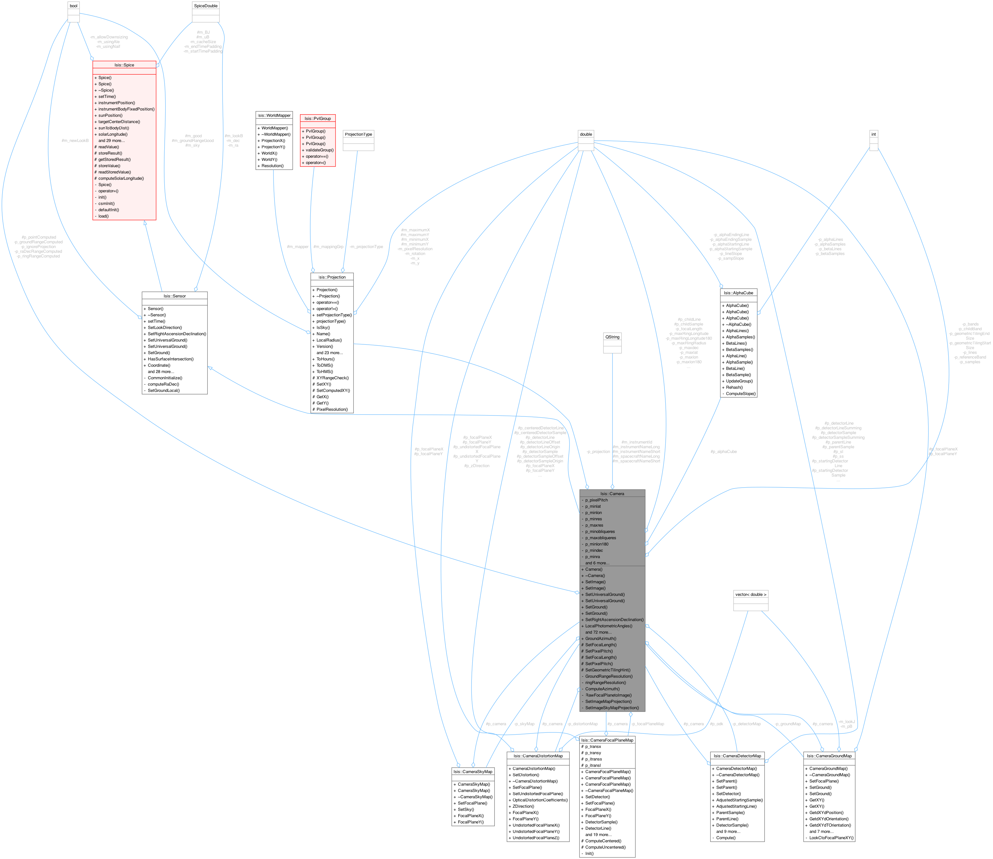
| CameraDistortionMap * | DistortionMap () |
| | Returns a pointer to the CameraDistortionMap object.
|
| |
| CameraFocalPlaneMap * | FocalPlaneMap () |
| | Returns a pointer to the CameraFocalPlaneMap object.
|
| |
| CameraDetectorMap * | DetectorMap () |
| | Returns a pointer to the CameraDetectorMap object.
|
| |
| CameraGroundMap * | GroundMap () |
| | Returns a pointer to the CameraGroundMap object.
|
| |
| CameraSkyMap * | SkyMap () |
| | Returns a pointer to the CameraSkyMap object.
|
| |
| QString | instrumentId () |
| | This method returns the InstrumentId as it appears in the cube.
|
| |
| QString | instrumentNameLong () const |
| | This method returns the full instrument name.
|
| |
| QString | instrumentNameShort () const |
| | This method returns the shortened instrument name.
|
| |
| QString | spacecraftNameLong () const |
| | This method returns the full spacecraft name.
|
| |
| QString | spacecraftNameShort () const |
| | This method returns the shortened spacecraft name.
|
| |
| void | SetDistortionMap (CameraDistortionMap *map, bool deleteExisting=true) |
| | Sets the Distortion Map.
|
| |
| void | SetFocalPlaneMap (CameraFocalPlaneMap *map) |
| | Sets the Focal Plane Map.
|
| |
| void | SetDetectorMap (CameraDetectorMap *map) |
| | Sets the Detector Map.
|
| |
| void | SetGroundMap (CameraGroundMap *map) |
| | Sets the Ground Map.
|
| |
| void | SetSkyMap (CameraSkyMap *map) |
| | Sets the Sky Map.
|
| |
| double | NorthAzimuth () |
| | Returns the North Azimuth.
|
| |
| double | SunAzimuth () |
| | Returns the Sun Azimuth.
|
| |
| double | SpacecraftAzimuth () |
| | Return the Spacecraft Azimuth.
|
| |
| double | OffNadirAngle () |
| | Return the off nadir angle in degrees.
|
| |
| void | IgnoreProjection (bool ignore) |
| | Set whether or not the camera should ignore the Projection.
|
| |
| void | LoadCache () |
| | This loads the spice cache big enough for this image.
|
| |
| std::pair< double, double > | StartEndEphemerisTimes () |
| | Calculates the start and end ephemeris times.
|
| |
| int | CacheSize (double startTime, double endTime) |
| | This method calculates the spice cache size.
|
| |
| void | GetGeometricTilingHint (int &startSize, int &endSize) |
| | This will get the geometric tiling hint; these values are typically used for ProcessRubberSheet::SetTiling(...).
|
| |
| bool | InCube () |
| | This returns true if the current Sample() or Line() value is outside of the cube (meaning the point must have been extrapolated).
|
| |
| virtual CameraType | GetCameraType () const =0 |
| | Returns the type of camera that was created.
|
| |
| virtual int | CkFrameId () const =0 |
| | Provides the NAIF frame code for an instruments CK kernel.
|
| |
| virtual int | CkReferenceId () const =0 |
| | Provides the NAIF reference code for an instruments CK kernel.
|
| |
| virtual int | SpkReferenceId () const =0 |
| | Provides reference frame for instruments SPK NAIF kernel.
|
| |
| virtual int | SpkTargetId () const |
| | Provides target code for instruments SPK NAIF kernel.
|
| |
| virtual int | SpkCenterId () const |
| | Provides the center of motion body for SPK NAIF kernel.
|
| |
| void | setTime (const iTime &time) |
| | By setting the time you essential set the position of the spacecraft and body as indicated in the class Spice.
|
| |
| bool | SetLookDirection (const double v[3]) |
| | Sets the look direction of the spacecraft.
|
| |
| bool | SetUniversalGround (const double latitude, const double longitude, bool backCheck=true) |
| | This is the opposite routine for SetLookDirection.
|
| |
| bool | SetUniversalGround (const double latitude, const double longitude, const double radius, bool backCheck=true) |
| | This overloaded method has the opposite function as SetLookDirection.
|
| |
| bool | SetGround (const SurfacePoint &surfacePt, bool backCheck=true) |
| | This overloaded method has the opposite function as SetLookDirection.
|
| |
| bool | HasSurfaceIntersection () const |
| | Returns if the last call to either SetLookDirection or SetUniversalGround had a valid intersection with the target.
|
| |
| void | Coordinate (double p[3]) const |
| | Returns the x,y,z of the surface intersection in BodyFixed km.
|
| |
| virtual double | UniversalLatitude () const |
| | Returns the planetocentric latitude, in degrees, at the surface intersection point in the body fixed coordinate system.
|
| |
| Latitude | GetLatitude () const |
| | Returns a planetocentric latitude object at the surface intersection point in body fixed.
|
| |
| virtual double | UniversalLongitude () const |
| | Returns the positive east, 0-360 domain longitude, in degrees, at the surface intersection point in the body fixed coordinate system.
|
| |
| Longitude | GetLongitude () const |
| | Returns a positive east, 0-360 domain longitude object at the surface intersection point in the body fixed coordinate system.
|
| |
| virtual SurfacePoint | GetSurfacePoint () const |
| | Returns the surface point (most efficient accessor).
|
| |
| Distance | LocalRadius () const |
| | Returns the local radius at the intersection point.
|
| |
| Distance | LocalRadius (Latitude lat, Longitude lon) |
| | Returns the local radius at the intersection point.
|
| |
| Distance | LocalRadius (double lat, double lon) |
| | Returns the local radius at the intersection point.
|
| |
| virtual double | PhaseAngle () const |
| | Returns the phase angle in degrees.
|
| |
| virtual double | EmissionAngle () const |
| | Returns the emission angle in degrees.
|
| |
| virtual double | IncidenceAngle () const |
| | Returns the incidence angle in degrees.
|
| |
| void | LookDirection (double v[3]) const |
| | Returns the look direction in the camera coordinate system.
|
| |
| virtual std::vector< double > | lookDirectionJ2000 () const |
| | Returns the look direction in the camera coordinate system.
|
| |
| virtual std::vector< double > | lookDirectionBodyFixed () const |
| | Returns the look direction in the body fixed coordinate system.
|
| |
| virtual double | RightAscension () |
| | Returns the right ascension angle (sky longitude).
|
| |
| virtual double | Declination () |
| | Returns the declination angle (sky latitude).
|
| |
| void | SpacecraftSurfaceVector (double scSurfaceVector[3]) const |
| | Sets the vector between the spacecraft and surface point in body-fixed.
|
| |
| virtual double | SlantDistance () const |
| | Return the distance between the spacecraft and surface point in kmv.
|
| |
| double | LocalSolarTime () |
| | Return the local solar time in hours.
|
| |
| virtual double | SolarDistance () const |
| | Returns the distance between the sun and surface point in AU.
|
| |
| double | SpacecraftAltitude () |
| | Returns the distance from the spacecraft to the subspacecraft point in km.
|
| |
| void | IgnoreElevationModel (bool ignore) |
| | This allows you to ignore the cube elevation model and use the ellipse.
|
| |
| void | instrumentPosition (double p[3]) const |
| | Returns the spacecraft position in body-fixed frame km units.
|
| |
| virtual SpicePosition * | instrumentPosition () const |
| | Accessor method for the instrument position.
|
| |
| virtual void | instrumentBodyFixedPosition (double p[3]) const |
| | Returns the spacecraft position in body-fixed frame km units.
|
| |
| virtual void | sunPosition (double p[3]) const |
| | Fills the input vector with sun position information, in either body-fixed or J2000 reference frame and km units.
|
| |
| virtual SpicePosition * | sunPosition () const |
| | Accessor method for the sun position.
|
| |
| virtual double | targetCenterDistance () const |
| | Calculates and returns the distance from the spacecraft to the target center.
|
| |
| virtual double | sunToBodyDist () const |
| |
| virtual Longitude | solarLongitude () |
| | Returns the solar longitude.
|
| |
| virtual void | instrumentBodyFixedVelocity (double v[3]) const |
| | Returns the spacecraft velocity in body-fixed frame km/sec units.
|
| |
| virtual iTime | time () const |
| | Returns the ephemeris time in seconds which was used to obtain the spacecraft and sun positions.
|
| |
| void | radii (Distance r[3]) const |
| | Returns the radii of the body in km.
|
| |
| virtual void | createCache (iTime startTime, iTime endTime, const int size, double tol) |
| | This method creates an internal cache of spacecraft and sun positions over a specified time range.
|
| |
| virtual iTime | cacheStartTime () const |
| | Accessor method for the cache start time.
|
| |
| virtual iTime | cacheEndTime () const |
| | Accessor method for the cache end time.
|
| |
| virtual void | subSpacecraftPoint (double &lat, double &lon) |
| | Returns the sub-spacecraft latitude/longitude in universal coordinates (0-360 positive east, ocentric)
|
| |
| virtual void | subSolarPoint (double &lat, double &lon) |
| | Returns the sub-solar latitude/longitude in universal coordinates (0-360 positive east, ocentric)
|
| |
| virtual Target * | target () const |
| | Returns a pointer to the target object.
|
| |
| QString | targetName () const |
| | Returns the QString name of the target.
|
| |
| virtual iTime | getClockTime (QString clockValue, int sclkCode=-1, bool clockTicks=false) |
| | This converts the spacecraft clock ticks value (clockValue) to an iTime.
|
| |
| SpiceDouble | getDouble (const QString &key, int index=0) |
| | This returns a value from the NAIF text pool.
|
| |
| SpiceInt | getInteger (const QString &key, int index=0) |
| | This returns a value from the NAIF text pool.
|
| |
| QString | getString (const QString &key, int index=0) |
| | This returns a value from the NAIF text pool.
|
| |
| virtual SpiceRotation * | bodyRotation () const |
| | Accessor method for the body rotation.
|
| |
| virtual SpiceRotation * | instrumentRotation () const |
| | Accessor method for the instrument rotation.
|
| |
| bool | isUsingAle () |
| |
| bool | hasKernels (Pvl &lab) |
| | Returns true if the kernel group has kernel files.
|
| |
| bool | isTimeSet () |
| | Returns true if time has been initialized.
|
| |
| SpiceInt | naifBodyCode () const |
| | This returns the NAIF body code of the target indicated in the labels.
|
| |
| SpiceInt | naifSpkCode () const |
| | This returns the NAIF SPK code to use when reading from SPK kernels.
|
| |
| SpiceInt | naifCkCode () const |
| | This returns the NAIF CK code to use when reading from CK kernels.
|
| |
| SpiceInt | naifIkCode () const |
| | This returns the NAIF IK code to use when reading from instrument kernels.
|
| |
| SpiceInt | naifSclkCode () const |
| | This returns the NAIF SCLK code to use when reading from instrument kernels.
|
| |
| SpiceInt | naifBodyFrameCode () const |
| | This returns the NAIF body frame code.
|
| |
| PvlObject | getStoredNaifKeywords () const |
| | This returns the PvlObject that stores all of the requested Naif data and can be a replacement for furnishing text kernels.
|
| |