ISIS Application Documentation
thmproc | Standard View | TOC | Home |
Runs a Themis cube through the processing for levels 0 and/or 2
Description
Categories
Groups
Examples
History
Description
Runs Mars Odyssey Themis images through the applications necessary to create a map projected product. There are two stages of processing, ingestion and mapping (radiometric calibration is assumed as Themis RDRs are available). Each stage can be disabled and runs all the programs necessary to complete that stage if not disabled.
All intermediate files will be generated in the users Isis temporary directory and deleted after they are no longer needed. In case of a catastrophic failure the intermediate files should be deleted. Their names will be the name of the application appended to the original file name followed by a 6 digit unique number.
Categories
Parameter Groups
Files
| Name | Description |
|---|---|
| FROM | Input Themis PDS RDR or an ISIS Themis level 1 cube |
| TO | Final output filename. |
| BANDS | Process a subset of bands |
| REMOVE | Remove Intermediate Files |
Level Processing
| Name | Description |
|---|---|
| Ingestion | Import and initialize a Themis EDR/RDR file. |
| Mapping | Process the input file through the map projection phase. |
Ingestion Parameters
| Name | Description |
|---|---|
| PCK | User defined target attitude and shape kernel file. |
| CK | User defined spacecraft pointing kernel file. |
| SPK | User defined spacecraaft position kernel file. |
| CKNADIR | Compute nadir pointing if no other kernels exist |
| SHAPE | Select the definition of the shape model |
| MODEL | User defined ISIS cube shape model. |
Mapping parameters
| Name | Description |
|---|---|
| MAP | File containing mapping parameters |
| PIXRES | Pixel resolution in meters |
Themis VIS Parameters
| Name | Description |
|---|---|
| VISCLEANUP | Run thmvistrim and thmvisflat |
Files: FROM
Description
Input filename. This file can be in one of two stages. A raw PDS Themis RDR or an ISIS Level 0/1 cube. The level 0/1 cube is assumed to have been run through thm2isis and spiceinit.
| Type | filename |
|---|---|
| File Mode | input |
| Filter | *.QUB *.imq *.img *.cub |
Files: TO
Description
Output filename from the last enabled processing sequence. By default the filename will be generated from the input filename with ".lev#" appended to the name, where "#" is the last level of processing (i.e., INGESTION = "lev1" or MAPPING = "lev2"). For ThemisVIS images, if processing is stopped at the ingestion phase, there will be an output cube for each frame in the image, with a ".frame#" appended to the end of the filename.
| Type | cube |
|---|---|
| File Mode | output |
| Internal Default | Automatic |
Files: BANDS
Description
This parameter allows the user to specify a sub-set of bands to process. Enter bands separated by commas (no spaces allowed). For example, 1,3,8 or 1-3,9 or 5
| Type | string |
|---|---|
| Internal Default | All |
Files: REMOVE
Description
This option allows the user to decide whether the intermediate files created in the thmproc application are to be deleted. The default value is TRUE.
| Type | boolean |
|---|---|
| Default | TRUE |
Level Processing: Ingestion
Description
Process the input file through all steps. This includes "thm2isis" and "spiceinit"
| Type | boolean |
|---|---|
| Default | YES |
| Inclusions |
|
Level Processing: Mapping
Description
Process the input file through level2. This includes cam2map.
| Type | boolean |
|---|---|
| Default | YES |
| Inclusions |
|
Ingestion Parameters: PCK
Description
Naif kernel file to be used for the target attitude and shape.
| Type | filename |
|---|---|
| File Mode | input |
| Default Path | $BASE/kernels/pck/ |
| Internal Default | none |
| Inclusions |
|
Ingestion Parameters: CK
Description
Naif kernel file to be used for the spacecraft pointing.
| Type | filename |
|---|---|
| File Mode | input |
| Default Path | $odyssey/kernels/ck/ |
| Internal Default | none |
| Inclusions |
|
Ingestion Parameters: SPK
Description
Naif kernel file to be used for the spacecraft position.
| Type | filename |
|---|---|
| File Mode | input |
| Default Path | $odyessy/kernels/spk/ |
| Internal Default | none |
| Inclusions |
|
Ingestion Parameters: CKNADIR
Description
Compute nadir pointing if no other kernels exist
| Type | boolean |
|---|---|
| Default | false |
Ingestion Parameters: SHAPE
Description
ISIS camera models can use a shape model (a projected ISIS cube that defines the radii for a global or regional area). You can choose to select a shape model or to use the definition of the ellipsoid found in the planetary constants (PCK) file.
| Type | string | ||||||||||||
|---|---|---|---|---|---|---|---|---|---|---|---|---|---|
| Default | SYSTEM | ||||||||||||
| Option List: |
|
||||||||||||
| Inclusions |
|
Ingestion Parameters: MODEL
Description
A map projected ISIS cube which contains the radii of the target. The file can cover more than the input cube (FROM) but must minimally cover the data in the input cube.
| Type | cube |
|---|---|
| File Mode | input |
| Default Path | $base//dems/ |
| Filter | *.cub |
Mapping parameters: MAP
Description
A file containing the desired output mapping parameters in PVL form. This file can be a simple hand produced label file. It can also be an existing cube label which contains a Mapping group.
| Type | filename |
|---|---|
| Internal Default | Sinusoidal |
| Inclusions |
|
| Filter | *.map |
Mapping parameters: PIXRES
Description
Specifies the resolution in meters per pixel. If not in the MAP file the resolution will be computed from the themis level 1 cube.
| Type | double |
|---|---|
| Internal Default | Automatic |
| Minimum | 0.0 (exclusive) |
| Inclusions |
|
Themis VIS Parameters: VISCLEANUP
Description
thmvistrim removes the overlap between framelets, which often contains both valid and invalid data. Set this to false to preserve this data. thmvisflat applies a flat-field correction to the data.
| Type | boolean |
|---|---|
| Default | true |
Examples
Example 1
Running this program on a Themis VIS EDR
Description
Command Line
GUI Screenshot
The GUI
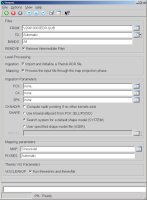
|
This is the default GUI This is what the GUI looks like when running this program with default parameters |
Input Image

Raw Data
|
Raw Input Data This is the raw input data |
Output Image
Final Output
|
The projected image (final output) This is the output from this program. It was cleaned up and projected. |
History
| Stuart Sides | 2004-01-16 | Original version |
| Jeff Anderson | 2004-02-26 | Changed mocproc into thmproc |
| Jeff Anderson | 2004-03-01 | Added Bands parameter and utilized IsisProcessExecutable class |
| Elizabeth Miller | 2005-12-08 | Fixed bug in output file naming |
| Elizabeth Miller | 2005-12-15 | Modified to output number of bands specified even when just doing ingestion |
| Elizabeth Miller | 2006-05-18 | Modified UI and parameters to be consistent with changes made to spiceinit |
| Elizabeth Miller | 2006-07-25 | Removed the AUTOLON parameter (no longer a parameter in cam2map) |
| Elizabeth Miller | 2006-09-08 | Added support for the themisVis camera model |
| Brendan george | 2006-09-26 | Documentation fixes |
| Elizabeth Miller | 2006-09-26 | Fixed bug in PIXRES use caused by changes in cam2map |
| Steven Lambright | 2007-11-06 | Added CKNADIR parameter for spiceinit. |
| Steven Lambright | 2008-06-13 | Updated to use new themis vis functionality. Instead of the themis images being split into a framelet per cube, they are now split into even and odd cubes. |
| Steven Lambright | 2008-07-16 | Updated to guarantee vis images have matching mapping groups, changed tempory file naming conventions, enabled thmvistrim on rdr files. |
| Steven Lambright | 2008-07-24 | Updated to fix problem with BANDS parameter. Before, the bands option would sometimes cause an error incorrectly. Also fixed a case where the input file would be deleted. |
| Steven Lambright | 2008-07-28 | Updated to fix problem with BANDS parameter with IR images. This parameter had a chance to not take effect. |
| Steven Lambright | 2008-08-04 | Updated to use new pipeline class. |
| Jeannie Backer | 2014-08-22 | Updated vis test truth data for the RDR cube due to a modified in the THEMIS VIS distortion map. Added vis test for EDR data with MAPPING=true. Added error test. Improved test coverage to 95/98/100%. References #1659. |
| Jeffrey Covington | 2015-01-27 | Removed unreachable code. |
| Makayla Shepherd and Andrew Stebenne | 2015-07-14 | Updated to fix a crash that occurs when invalid files are passed in as parameters. Fixes #1025. |