This application takes a control net and outputs the same data avalible from
campt for every control measure in the control net. It also outputs data
about the measure and point. This data is formated as a flat file and is
comma seperated so it can be imported to Excel. The columns titles in the
file are:
Added ALLOWOUTSIDE option
default behavior not modified at all.
Mackenzie Boyd
2010-03-25
Change to CameraPointInfo added two parameters to output and modified
two Output now had PositiveEast360Longitude and PositiveWest180Longitude.
Also made append option more forgiving so that it will create a file if
none exists.
Mackenzie Boyd
2010-05-24
Added option to allow for errors so that instead of crashing the program
continues and reports the errors in the output file.
Mackenzie Boyd
2010-06-07
Updated and added to documentation.
Christopher Austin
2010-06-08
Gave cnettable the ability to compile
Mackenzie Boyd
2011-04-11
Modified outputs which would have been Isis::Null double values to now
be empty strings.
James Alexander Crough
2011-07-19
Made the software output all of the log values in addition to the normal
output of the software.
Jeannie Backer
2014-08-22
Updated truth data due to modifications, printing NULL instead of N/A. References #1659.
Tyler Wilson
2014-08-17
Updated application truth data due to modifications in CameraPointInfo class.
References #476.
Kaj Williams
2017-04-21
Trimmed extra commas from label and data.
References #4657.
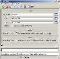
If checked this option allows file output to be appended to a file or
create a new file. If the file already exists and append is off the
program will overwrite the existing file.
When checked sample/line values that are outside of the images (but
close) will be extrapolated. For example a sample of -0.5 would be
valid. If this is not checked a sample of -0.5 is not allowed.
If errors occur such as values not having an intersection with the
body or sample line locations outside of the cube with ALLOWOUTSIDE
not checked the program will continue and report the error and reason
to the file. If no errors occur "N/A" is put into the column,
otherwise, the reason for the error is written to the file.
This is an example of how to use cnettable to produce a flatfile
or csv file for excel or other uses. The required elements are a list
of cubes and a corresponding control network. The easiest way to get
this is to run findimageoverlaps on a list of cubes and then autoseed
this list with the overlaps.
This file contains the output of a run of cnettable on a very small
control network. It shows all the expected data for the program and
the format the data is in.