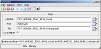
HiSharpen uses a linear frequency domain filter to remove the minor
blur caused by the optical system of the HiRISE camera.
Overview
Parameters
Example 1
Description
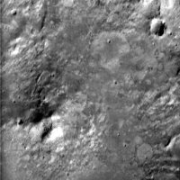
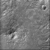
HiSharpen uses a linear frequency domain filter to remove the minor
blur caused by the optical system of the HiRISE camera. This blur is
estimated from prelaunch measurements of the camera's point spread
function (PSF) supplied by Alan Delamere of Ball Aerospace. The
program accepts as input a HiRISE subimage of dimensions 2**n square.
The program determines which filter (Red, BG, IR) was used for
acquiring the HiRISE image and then selects the corresponding PSF and
scales it to match the dimensions of the input image. First, the
Fourier transforms of both the image and the PSF are calculated using
the Fast Fourier Transform (FFT) algorithm. Next, the transform of the
image is divided by the transform of the PSF (the Modulation Transfer
Function, or MTF). The quotient is then transformed back to the
spatial domain by an inverse FFT.
Note that no pre-whitening or other noise suppression is done by
HiSharpen. Random noise and pixel-to-pixel variations will be
accentuated by HiSharpen unless steps have been taken to reduce the
noise in the input image prior to sharpening.
Note also that the FFT algorithm assumes that the input image is
periodic, i.e. the left side of the image is repeated when the right
edge of the image is reached. HiSharpen may therefore produce severe
ringing in input images with low spatial frequency variations.