ISIS Application Documentation
maptrim | Printer Friendly View | TOC | Home |
Trim edges of a map projected image
| Overview | Parameters | Example 1 | Example 2 |
DescriptionThis program trims map projected images and sets valid pixels that fall outside a specified bounding box to NULL. By default, the pixels that fall outside the minimum and maximum latitude and longitude found within the Mapping Group of the input cube's label are set to NULL. The values entered for minimum and maximum latitude and longitude must be in the same longitude domain, longitude direction, and latitude type as the settings in the input image labels within the Mapping Group. If the values entered are in a different longitude domain, they will be interpreted as the domain setting in the image labels, and the entire output cube could contain only NULL pixels. For example, if the input cube's Mapping Group has a longitude direction of positive east and the user specifies values in west longitude, the longitude direction will be interpreted as positive east.
Warnings:
Mapping information updated after image is cropped:
Mosaicking cropped images: Note: This application does not handle non-projected images (i.e. images that are not Level2 or a mosaic). To trim a Level1 image, please refer to camtrim. CategoriesRelated Applications to Previous Versions of ISISThis program replaces the following application existing in previous versions of ISIS:
Related Objects and DocumentsApplicationsHistory
|
Parameter GroupsFiles
Trim options
Trim Parameters
|
Files: FROM
Description
Use this parameter to specify the input filename. The selected option will be applied to all the bands in the file by default, or the selected bands.
| Type | cube |
|---|---|
| File Mode | input |
| Filter | *.cub |
Files: TO
Description
This output file will contain the results of the selected MODE option.
| Type | cube |
|---|---|
| File Mode | output |
| Filter | *.cub |
Trim options: MODE
Description
This parameter allows the user to select a trim option. By default, all pixels outside the default or specified latitude and longitude range are set to NULL. To override the default, select CROP or BOTH.
| Type | string | ||||||||||||
|---|---|---|---|---|---|---|---|---|---|---|---|---|---|
| Default | TRIM | ||||||||||||
| Option List: |
|
Trim Parameters: MINLAT
Description
Specify the starting latitude of range to exclude from processing. Any pixel whose latitude is less than this value will be set to NULL and/or trimmed.
| Type | double |
|---|---|
| Internal Default | Minimum latitude in labels |
| Minimum | -90 (inclusive) |
| Maximum | 90 (inclusive) |
| Less Than | MAXLAT |
Trim Parameters: MAXLAT
Description
Specify the ending latitude of range to exclude from processing. Any pixel whose latitude is greater than this value will be set to NULL and/or trimmed.
| Type | double |
|---|---|
| Internal Default | Maximum latitude in labels |
| Minimum | -90 (inclusive) |
| Maximum | 90 (inclusive) |
| Greater Than | MINLAT |
Trim Parameters: MINLON
Description
Specify the starting longitude of range to exclude from processing. Any pixel whose longitude is less than this value will be set to NULL and/or trimmed.
| Type | double |
|---|---|
| Internal Default | Minimum longitude in labels |
| Minimum | -360 (inclusive) |
| Maximum | 360 (inclusive) |
| Less Than | MAXLON |
Trim Parameters: MAXLON
Description
Specify the ending longitude of range to exclude from processing. Any pixels whose longitude is greater than this value will be set to NULL and/or trimmed.
| Type | double |
|---|---|
| Internal Default | Maximum longitude in labels |
| Minimum | -360 (inclusive) |
| Maximum | 360 (inclusive) |
| Greater Than | MINLON |
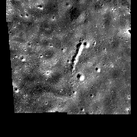
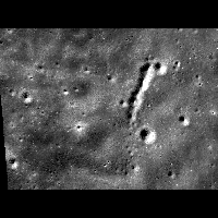
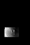
Example 1Trim a projected image Description
This example illustrates how to trim a cube that is projected to a
sinusoidal projection. All pixels that have latitudes less than 15°
or greater than 20° and longitudes less than 222° or greater
than 230° are set to NULL. The TRIM option is used since no option is
selected.
Command Line
maptrim
FROM=input.cub TO=trimmed.cub MINLAT=15 MAXLAT=20 MINLON=222
MAXLON=230
Command to run maptrim in the command line mode to set all
pixels outside the specified bounding box to NULL.
Input Image
Output Image
|
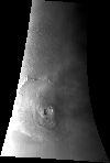
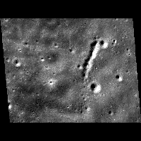
Example 2Trim a projected image using CROP and BOTH options Description
This example illustrates how to trim a cube that is projected to a
sinusoidal projection. The first part will crop the image to
a specified bounding box, and the second part will set pixels outside
the bounding box to NULL.
Command Line
maptrim
FROM=LMMP_SAB_sinu.cub to=sinu_crop.cub mode=crop minlat=-60.5836
maxlat=-60.3129 minlon=-161.07 maxlon=-160.377
Command to run maptrim in the command line mode to extract
the specified bounding box from the input cube.
Input Image
Output Images
|