Trims pixels outside of phase, incidence, and emission angles
Overview
Parameters
Example 1
Example 2
Description
The photrim program trims pixels outside of the phase, incidence, and emission
angles by setting them to "null" within all bands of the cube. A user can either
trim using the program's default method or the USEDEM method.
By default, photrim uses the angles calculated from the ellipsoidal surface to
trim an image. The ellipsoid is retrieved from the IAU/NAIF target body file,
which is defined within the cube's kernel group as the TargetAttitudeShape. If
the USEDEM option is selected, then photrim will use the angles calculated from the
digital elevation model (DEM) to perform the trim instead. The DEM is referenced
in the ShapeModel keyword within the input cube's kernel group. Note that
photrim does not trim using local slopes.
Angle Definitions:
Phase Angle - The angle between the sun vector to a point on the ellipsoid
and the instrument vector to the same point.
Incidence Angle - The angle between the sun vector to a point on the
ellipsoid and the normal at that point.
Emission Angle - The angle between the instrument vector to a point on the
ellipsoid and the normal at that point.
Examples of special cases:
1) If the instrument is directly between the point and the sun, then the
phase angle is 0; if both the sun and the instrument are both along the
normal to the point, then the phase, incidence and emission angles are all
zero.
2) If the instrument is looking along the normal and the sun is
illuminating the point, then the emission angle is 0 and the incidence and
phase angles will be in the range of 0 to 90 and equal to each other.
3) A point on the surface of an ellipsoidal body cannot be illuminated if the
incidence angle is greater than 90 degrees.
4) A point on the surface of an ellipsoidal body cannot be visible if the
emission angle is greater than 90 degrees.
5) If a point is both illuminated and visible, then the phase angle ranges
from 0 to less than 180.
This program replaces the following
application
existing in previous versions of ISIS:
trimangle
History
Tammy Becker
1999-02-11
Original version
Stuart Sides
2003-06-04
Converted trimandle to Isis 3.0, and made it trim only on phase, incidence
and emission angles.
Stuart Sides
2003-07-29
Modified filename parameters to be cube parameters where necessary
Steven Lambright
2008-05-13
Removed references to CubeInfo
Marjorie Hahn
2016-08-05
Added the option to use the digital elevation model when trimming the image.
Created examples for using the DEM and not using the DEM. Fixes #4181.
Converted to callable app and converted Makefile tests to gtests.
This specifies if the image will be trimmed based on the photometric
angles obtained from the DEM surface or the ellipsoid. If this parameter
is set to false, then the photometric angles will be obtained from the
ellipsoidal surface.
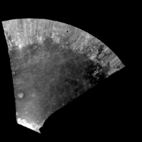
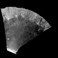
Run photrim using the digital elevation model and a max emission value of 88.
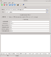
GUI Screenshot
Example Gui
Example Gui
Screenshot of the photrim GUI with a max emission angle of 88 degrees and with
the option to use the digital elevation model selected. The rest of the parameters
are set to the defaults.
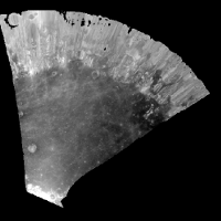
Input Image
Input Cube
Input Cube
Parameter Name:
FROM
The untrimmed cube. This is an oblique view of the moon acquired by the Apollo Metric camera.
Output Image
Output Cube
Output Cube
Parameter Name:
TO
The result of trimming the input cube using the DEM and a max emission angle of 88 degrees.