

fplanemap
Produce focal plane coordinates from control net file
fplanemap produces a comma separated value (CSV) file containing focal plane coordinates from a control network file. The file is assumed to originate from a coreg run comparing two files either in camera or projected space.
Typical processing strategies would include identifying a trusted source image (truth or MATCH file used in coreg ) that has no distortion and comparable resolution. The registration of the truth image to the image requiring analysis (FROM) should produce strong correlations for the best results. Areas of least variation in topography will also contribute to better results.
This application was developed primarily to analyze image distortion, which is very sensitive to correlation imperfections. The content of the CSV output TO file contains all the information necessary to apply linear or least square fits to equations. The following describes the output CSV file format.
The output TO CSV file contains 11 columns. Note that a camera model for the FROM file is required since it is used to get the actual focal plane coordinates. The sample and line coordinates recorded in the output file will be the same as in the control net file. The sample/line coordinate provided there is used to determine the latitude and longitude of the coordinate. Below is a small portion of an output TO CSV file:
OldSample,OldLine,NewSample,NewLine,X,Y,XC,YC,GoodnessOfFit,Latitude,Longitude
51,3,46.5738,6.52725,-0.125346,3.18205,-0.152566,3.58934,0.514252,32.2544,82.1228
17,37,22.0716,36.9117,-0.0278861,3.11492,-0.030747,3.51921,0.44952,32.2264,82.0898
51,37,54.8234,41.0111,-0.025531,3.18319,-0.0403855,3.6141,0.543963,32.2264,82.1228
84,37,86.1196,39.766,-0.0232456,3.24823,-0.0344203,3.70423,0.225104,32.2264,82.1548
51,43,49.5502,46.0587,-0.0410861,3.18351,-0.055586,3.59933,0.255932,32.2215,82.1228
51,49,51.7797,45.6973,-0.0566404,3.18382,-0.0543615,3.60573,0.347588,32.2165,82.1228
84,49,90.1357,49.14,-0.0541637,3.24884,-0.0616203,3.71664,0.446062,32.2165,82.1548
17,55,15.761,61.5159,-0.0748423,3.11587,-0.103437,3.5031,0.204652,32.2116,82.0898
51,55,48.6316,58.2457,-0.0721934,3.18412,-0.0914211,3.59775,0.383612,32.2116,82.1228
84,55,89.9976,55.097,-0.0696208,3.24915,-0.0791061,3.71678,0.338814,32.2116,82.1548
17,60,11.4821,61.6077,-0.0878837,3.11609,-0.10402,3.49073,0.436698,32.2074,82.0898
51,60,48.1177,61.9931,-0.0851532,3.18435,-0.102458,3.59659,0.266318,32.2074,82.1228
84,60,89.7459,59.6435,-0.0825007,3.24938,-0.0924634,3.71647,0.326716,32.2074,82.1548
17,66,14.9112,70.9194,-0.103532,3.11635,-0.13111,3.50144,0.365906,32.2025,82.0898
Analysis of the data may result in adjustments to the boresight and/or the distortion model. The plot below is derived from the data from the above file.
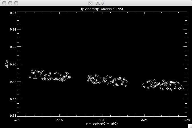
This data as plotted can be used to derive distortion model parameters by fitting a line through the data.
The following table describes each column:
CSV Output Columns
| Column | Description |
|---|---|
| OldSample | The original sample coordinate of the point at the center of the registration pixel location. This coordinate comes from the MATCH file in coreg. |
| OldLine | The original line coordinate of the point at the center of the registration pixel location. This coordinate comes from the MATCH file in coreg. |
| NewSample | The registered sample coordinate from the FROM file in coreg and fplanemap . |
| NewLine | The registered line coordinate from the FROM file in coreg and fplanemap. |
| X | The distorted focal plane X coordinate (xd) that maps from the old distorted pixel location (OldSample, OldLine). The units are typically in millimeters. |
| Y | The distorted focal plane Y coordinate (yd) that maps from the old distorted pixel location (OldSample, OldLine). The units are typically in millimeters. |
| XC | The undistorted focal plane X coordinate (xc) that maps from the new distorted pixel location (NewSample, NewLine). The units are typically in millimeters. |
| YC | The undistorted focal plane Y coordinate (yc) that maps from the new distorted pixel location (NewSample,NewLine). The units are typically in millimeters. |
| GoodnessOfFit | The coorelation coefficient as found in the control net file that indicates the quality of the registration for the point |
| Latitude | The latitude of the OldSamp/OldLine coordinate |
| Longitude | The longitude of the OldSample/OldLine coordinate |
Categories
History
| Kris Becker | 2010-09-24 | Original Version |
Parameters
Files
| Type | cube |
|---|---|
| File Mode | input |
| Filter | *.cub |
This file will contain the ControlNet created from the run of a co-registration application such as coreg. There are checks made to ensure that it satisfies expected conditions of a output control net from one of these types of applications.
There must be only two measures to a control point. One must be designated the reference. Points that have the Ignore property set to true are not considered in this application.
| Type | filename |
|---|---|
| File Mode | output |
| Filter | *.net *.pbnet |
| Type | filename |
|---|---|
| File Mode | output |
| Internal Default | None |
| Filter | *.csv |
Options
| Type | double |
|---|---|
| Default | 5.0 |
| Type | boolean |
|---|---|
| Default | False |