

camtrim
Trims pixels outside of lat/lon range
This application trims pixels outside of a user-specified
latitude/longitude range. Pixels that are outside of
the lat/lon range are set to NULL in the resulting
cube. By default, the lat/lon range is in the
universal coordinate system. This can be overridden using a map
projection template file.
Note: This application will not handle projected images (i.e. Level2). This program is meant to work specifically on Level1 images. To trim Level2 images, please refer to maptrim.
Note: This application will not handle projected images (i.e. Level2). This program is meant to work specifically on Level1 images. To trim Level2 images, please refer to maptrim.
Categories
History
| Jeff Anderson | 2003-04-28 | Original version |
| Jeff Anderson | 2003-04-28 | Added program to the Cameras category |
| Jeff Anderson | 2003-04-29 | Fixed bug in the Xml file |
| Jeff Anderson | 2003-04-30 | Fixed problem with projection manager prematurely destroying projection object |
| Stuart Sides | 2003-05-16 | Modified schema location from astogeology... to isis.astrogeology..." |
| Jeff Anderson | 2003-06-04 | Added dependent multi-band capabilities |
| Stuart Sides | 2003-07-29 | Modified filename parameters to be cube parameters where necessary |
| Jacob Danton | 2005-12-02 | Added appTest |
| Elizabeth Miller | 2006-05-18 | Depricated CubeProjection and ProjectionManager to ProjectionFactory |
| Steven Lambright | 2008-05-12 | Removed references to CubeInfo |
| Travis Addair | 2009-08-10 | Mapping group parameters are now placed into the print file. |
| Jai Rideout | 2012-01-11 | Updated documentation and testing with Ella Lee in preparation for the 3.4.0 release. Fixed various inconsistencies in the documentation and rewrote some parts to make it clearer. Added two examples. Added a check to ensure that projected cubes cannot be used with this application. Added two new tests to test the processing of level 2 cubes and the use of a map template file. |
| Tracie Sucharski | 2012-12-06 | Changed to use TProjection instead of Projection. References #775 |
Parameters
Files
Use this parameter to select the input cube filename. All bands within
the cube will be trimmed.
| Type | cube |
|---|---|
| File Mode | input |
| Filter | *.cub |
This file will contain the trimmed cube.
| Type | cube |
|---|---|
| File Mode | output |
If a file is not provided, this program will use the planetocentric
latitude type, positive east longitude direction, and 360 longitude
domain. Otherwise, the labels (LatitudeType, LongitudeDomain, and
LongitudeDirection) in the map projection template file will determine
the lat/lon type, direction, and domain.
| Type | filename |
|---|---|
| File Mode | input |
| Default | None |
Ground Range
Pixels that have a latitude less than this value will be trimmed.
| Type | double |
|---|---|
| Minimum | -90 (inclusive) |
| Maximum | 90 (inclusive) |
| Less Than | MAXLAT |
Pixels that have a latitude greater than this value will be trimmed.
| Type | double |
|---|---|
| Minimum | -90 (inclusive) |
| Maximum | 90 (inclusive) |
| Greater Than | MINLAT |
Pixels that have a longitude less than this value will be trimmed.
| Type | double |
|---|---|
| Minimum | -360 (inclusive) |
| Maximum | 360 (inclusive) |
| Less Than | MAXLON |
Pixels that have a longitude greater than this value will be trimmed.
| Type | double |
|---|---|
| Minimum | -360 (inclusive) |
| Maximum | 360 (inclusive) |
| Greater Than | MINLON |
Example 1
Trimming Pixels
This example illustrates how to trim a cube such that all pixels with
latitudes greater than 25 are set to NULL.
Command Line
The command to use for this example.
camtrim
          FROM=input.cub TO=trimmed.cub MINLAT=-90 MAXLAT=25
          MINLON=0 MAXLON=360
Input Image
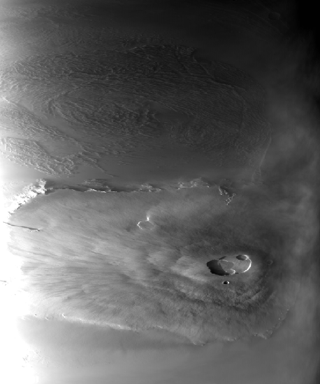
Input cube
input.cub
Parameter Name:
FROM
This is the input cube to trim.
Output Image
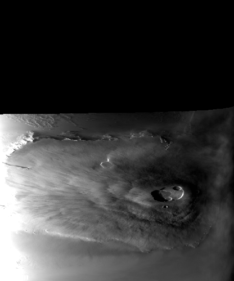
Trimmed cube
trimmed.cub
Parameter Name:
TO
This is the trimmed cube. Notice the NULL pixels with latitudes greater than 25 degrees.
Example 2
Trimming Pixels Using a Map Projection Template File
This example illustrates how to trim a cube such that only pixels
between longitudes 134 and 136 are kept. All other pixels are set to
NULL. The map projection template file specifies planetographic
latitudes and -180 to 180 positive west longitudes, instead of using
planetocentric latitudes and 0 to 360 positive east longitudes (the
default).
Command Line
The command to use for this example.
camtrim
          FROM=input.cub TO=trimmed_lon.cub MAP=sinusoidal.map MINLAT=-90
          MAXLAT=90 MINLON=134 MAXLON=136
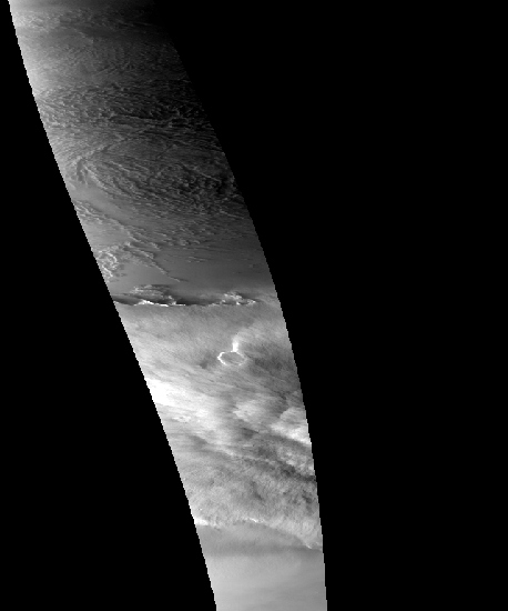
Input Image
Input cube
input.cub
Parameter Name:
FROM
This is the input cube to trim.
Data File
Links open in a new window.| Map projection template file | This is the map projection template file that is used to specify the latitude type, longitude direction, and longitude domain. The three keywords of interest in this file are LatitudeType, LongitudeDirection, and LongitudeDomain. |
|---|
Output Image
Trimmed cube
trimmed_lon.cub
Parameter Name:
TO
This is the trimmed cube.