

cnetnewradii
Generate new radii from DEM for a ControlNet
This application will go through an existing control network and copy it to a new control network updating either apriori or adjusted radii values using the given shape file. When it encounters a point type of Fixed or Constrained it will use the control point latitude and longitude to update the radius from the shape model file. The radius will be calculated based on a bilinear interpolation of the closest pixels in the shape file. The AprioriRadius, AprioriRadiusSource and AprioriRadiusSourceFile will be updated if GETLATLON=APRIORI. The AdjustedRadius will be updated if GETLATLON=ADJUSTED. There are not keywords for AdjustedRadiusSource or AdjustedRadiusSourceFile.
If, for a particular point, the application fails to calculate a radius using the shape file, then the input radius value is kept and the point is set to Ignore=true. The number of these failures are recorded in the application's log. The Point IDs for the corresponding control points will be listed in the ERRORS log output file. If the user did not enter a filename for this log and there are any points that failed, one will be created with the name "failures.log". Note:If a significant number of points in the control network fail to find a new radius value, the user should make sure that they have input the correct shape model for the input control network.
Categories
History
| Steven Koechle | 2008-08-05 | Original Version |
| Jeannie Walldren | 2010-05-25 | Modified to handle control points that fail to calculate a new radius as explained in the description. Added ERRORS parameter to list PointIDs of the control points that failed to calculate a new radius. Added filters for input and output parameters. |
| Jeannie Walldren | 2010-05-27 | Created examples. |
| Christopher Austin | 2011-01-19 | Altered to compile with the new Control redesign. |
| Steven Lambright | 2011-02-09 | Updated to not try to project null lat,lon values |
| Christopher Austin | 2011-03-14 | Updated for Control Point's removal of Set/GetSurfacePoint() and added the GetLatLon parameter. |
| Steven Lambright | 2011-04-11 | Changed the DEM parameter name to MODEL |
| Debbie A. Cook and Tracie Sucharski | 2011-06-07 | Changed the point type "Ground" to "Fixed" |
| Tracie Sucharski | 2011-07-28 | Change radii values for both Fixed and Constrained points. Use bilinear interpolation to get the correct radius from the shape file. This uses the same interpolation as the camera. Print error if there are no Fixed or Constrained points in the network. Change input parameter names to be consistent with those suggested on the Astrogeology wiki page. Removed NETWORKID as user parameter since it should carry the ID from the input control net. Set Apriori as the default for the GETLATLON parameter. Update examples documentation. |
| Tracie Sucharski | 2011-10-04 | Skip edit locked points, keep count for summary. Added appTest for edit locked points. |
| David L Miller | 2015-06-29 | Updated Makefile to be closer to new Isis coding standards and fixed bug where test data coming from directories that don't start with "/usgs/" would not be found. |
Parameters
Files
| Type | filename |
|---|---|
| File Mode | input |
| Filter | *.net |
| Type | cube |
|---|---|
| File Mode | input |
| Default Path | $base/dems/ |
| Filter | *.cub |
| Type | filename |
|---|---|
| File Mode | output |
| Filter | *.net |
| Type | filename |
|---|---|
| File Mode | output |
| Internal Default | No Error Output |
| Filter | *.log *.pvl *.txt |
Parameters
| Type | string | |||||||||
|---|---|---|---|---|---|---|---|---|---|---|
| Default | APRIORI | |||||||||
| Option List: |
|
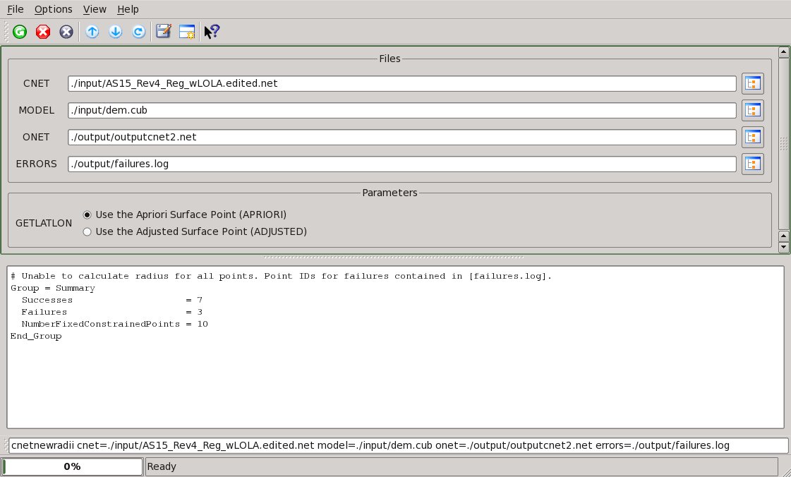
Example 1
All fixed points successfully updated
Command Line
cnetnewradii
          cnet=../IN/inputcnet.net model=../IN/inputDEM1.cub
          onet=../OUT/ouputcnet1.net getlatlon=APRIORI
GUI Screenshot

Example GUI
Screen shot of GUI with parameters filled in to create control network with new radii values.
Input Image
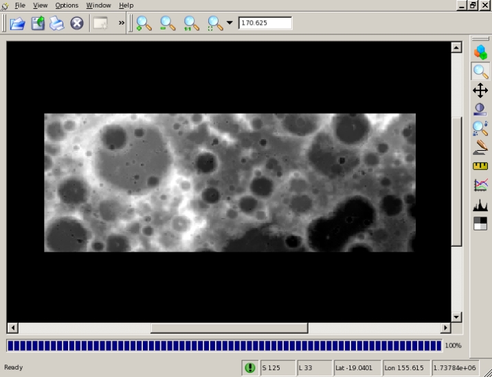
Input shape file for cnetnewradii
SHAPE
Parameter Name:
SHAPE
Example of an input shape cube used by cnetnewradii to update the radii values of contrained and fixed points in the control network.
Data Files
Links open in a new window.| Input ControlNet for cnetnewradii | Example of an input control network whose radii values will be updated. |
|---|---|
| Output control network for cnetnewradii | Example of an output control network corresponding to the input example with updated radii values. Notice that radii values have been updated for all contrained and fixed points. |
Example 2
Some fixed points fail to be updated
Command Line
cnetnewradii
          cnet=../IN/inputcnet.pvl model=../IN/inputDEM2.cub
          onet=../OUT/ouputcnet2.pvl errors=../OUT/failures.pvl
GUI Screenshot
Example GUI
Screen shot of GUI with parameters filled in to create control network with new radii values.
Input Image
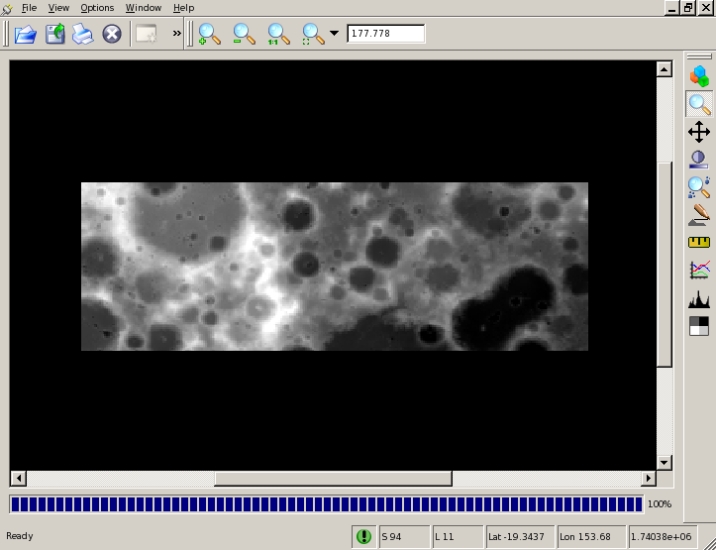
Input shape cube for cnetnewradii
SHAPE
Parameter Name:
DEM
Example of an input shape cube used by cnetnewradii to update the radii values of fixed points in the control network.
Data Files
Links open in a new window.| Input control network for cnetnewradii | Example of an input control network whose radii values will be updated. |
|---|---|
| Output error log for cnetnewradii | Example of an output error log containing the PointIDs of all points that failed to calculate a new radius value. |
| Output control network for cnetnewradii | Example of an output control network corresponding to the input example with updated radii values. Notice that the fixed points that failed are set to Ignore=True and their original radii values are retained. |