

gllnims2isis
Import a Galileo Near Infrared Mapping Spectrometer (NIMS) cube into ISIS cube format. Note: This application only works with the original PDS3 archive. This routine was created to restore the NIMS tube/gcube data and migrate to PDS4.
This application only works with the original PDS3 archive. This routine was created to restore the NIMS tube/gcube data and migrate to PDS4 which has been released here.
This program will read and convert a PDS formatted Galileo Near Infrared Mapping Spectrometer file (downloaded as a *.qub file from a USGS PDS imaging node server) into two ISIS cubes. The first (CORE) cube contains primary mission data, and the second (SUFFIX) cube contains additional backplane data. The user must choose a path to an input NIMS cube, and an output path and name for both the core and suffix cubes.
The projections used for the original qube files are not compatible with ISIS projections, so projected Galileo NIMS qubes cannot be converted into equivalent ISIS cubes with mapping information directly. Instead, imported NIMS ISIS cubes are provided with a MappingInformation PVL group in the cube label. The information in this PVL group and latitude and longitude information from the output suffix cube can be used with the nocam2map ISIS application to produce a projected image. An example follows.
To use nocam2map in this way, first convert the Galileo NIMS PDS qube into an ISIS cube using gllnims2isis:
gllnims2isis from=original.qub core=core.cub suffix=suffix.cubThen, extract latitude and longitude cubes from the suffix cube. The first band is latitude, the second is longitude:
  cubeatt from=suffix.cub+1 to=latitude.cub
  cubeatt from=suffix.cub+2 to=longitude.cub
Next, use information from core.cub's MappingInfo PVL group to run nocam2map. Here is an example of the information contained in a MappingInfo PVL group:
  Group = MappingInformation
    LatitudeType            = Planetocentric
    LongitudeDirection      = PositiveWest
    MapResolution           = 0.334 <pixels/degree>
    MinimumLatitude         = -80.53 <degrees>
    MaximumLatitude         = 75.99 <degrees>
    MinimumLongitude        = 0.06 <degrees>
    MaximumLongitude        = 176.90 <degrees>
    MapProjectionType       = POINT_PERSPECTIVE
    MapScale                = 95.548 <km/pixel>
    MapProjectionRotation   = 0.22 <degrees>
    MajorEquatorialRadius  = 1830.00 <km>
    MinorEquatorialRadius = 1818.70 <km>
    PolarRadius             = 1815.30 <km>
  End_Group
This information can be used to run nocam2map to project this cube into an ISIS-compatible projection. As you can see below, the MajorEquatorialRadius in the MappingInformation PVL group above lists the EQURADIUS to use in nocam2map, the PolarRadius lists the value to use for POLRADIUS, and the MapResolution is the value to use for RESOLUTION in nocam2map.
  nocam2map from=core.cub latcube=latitude.cub loncube=longitude.cub londir=positivewest to=projected.cub pixres=ppd resolution=0.334
  equradius=1830.00 polradius=1815.30
It isn't required, but the minimum and maximum latitude and longitude from the MappingInformation group can also be used in nocam2map to define the output range of the projection. For defining the projection to use, either a pre-existing map template can be used, or a new mapping label can be created from the information in the MappingInformation group.
See Also:
- The Near Infrared Mapping Spectrometer Experiment on Galileo
-
Planetary Science Data Dictionary Document
A standard reference for data product descriptions contained in Planetary Data System (PDS) data catalogs.
A detailed description of the Galileo NIMS instrument.
Note:
Now that the data has been migrated to PDS4, this routine should not be needed for ingesting Galileo NIMS tube/gcube data. The PDS4 migrated files are stored in a "raw" ISIS3+ cube format with a PDS4 label. Thus applications which have support for ISIS3+ cube format or the PDS4 format should be able to directly use them. For more about how the data was migrated, please see the readme.pdf from the new archive or the Cahill et al., 2017 LPSC abstract.
Cahill, J. T. S., K. Becker, R. Espiritu, C. Isbell, and F. P. Seelos (2017), Galileo NIMS: New ISIS3 tools for modernized data set handling and PDS4 re-archival, Planetary Data Workshop, 3, abs. 7071.
Categories
History
| Tyler Wilson | 2016-02-25 | Original version |
| Jeannie Backer | 2016-03-15 | Modified error throw to not append a caught message to the current message. This was printing non UTF-8 characters on some platforms. Updated truth data. |
| Jesse Mapel | 2016-10-08 | Modified to import the PDS mapping group. |
| Kristin Berry | 2016-12-28 | Took out the PDS mapping group because they don't match ISIS Projection standards. Instead a MappingInformation PVL group was added, along with documentation about how to use nocam2map with this information to create a valid projected ISIS Cube. |
Parameters
Files
| Type | filename |
|---|---|
| File Mode | input |
| Filter | *.qub |
| Type | cube |
|---|---|
| File Mode | output |
| Filter | *.cub |
| Type | cube |
|---|---|
| File Mode | output |
| Filter | *.cub |
Example 1
Importing a NIMS cube
Command Line
gllnims2isis
          from=../go_1120/jupiter/33j002tr.qub
          core=../go_1120/jupiter/33j002tr_core.cub
          suffix=../go_1120/jupiter/33j002tr_suffix.cub
GUI Screenshot
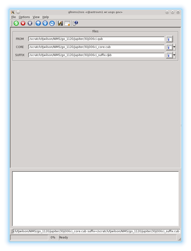
Example GUI
gllnims2isis GUI.Screenshot of the GUI with parameters filled in to execute the gllnims2isis application. Output cubes for core and suffix data are always required.
Output Images
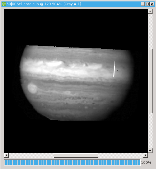
Output image of core data.
Output core data cube.
Parameter Name:
TO
Output image of core data after gllnims2isis has imported it to ISIS.
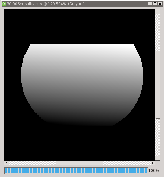
Output image of suffix data.
Output suffix data cube.
Parameter Name:
TO
Output image of suffix (backplane) data after gllnims2isis has imported it to ISIS.