

map2map
Modify a cube's map projection
      1.  Converting from Sinusodial to Mercator or any other
          supported projection
      2.  No projection change but altering projection parameters
          such as center longitude or standard parallels
      3.  No projection change but altering pixel resolution
      4.  No projection change but altering latitude/ longitude window
      5.  No projection change but altering latitude types,
          longitude domains, or longitude direction
      6.  Match the mapping parameters of another ISIS leve2 cube for
          comparison.
If you need to generate your own map file you can use the maptemplate program or alternatively, hand create a file using your favorite editor. The map file need only specify the ProjectionName as defaults will be computed for the remaining map file parameters.
The map file can be an existing map projected (level2) cube. A level2 cube has PVL labels and contains the Mapping group. Depending on the values of the input parameters, the output cube can use some or all of the keyword values of the map file. For instance, setting MATCHMAP = true causes all of the mapping parameters to come from the map file, resulting in an output cube having the same number of lines and samples as the map file. If MATCHMAP = true and the map file is missing a keyword like PixelResolution, the application will fail with a PVL error. Setting MATCHMAP=false allows for some of the mapping components to be overridden by the user or computed from the FROM cube.To learn more about using map projections in ISIS, refer to the ISIS Workshop "Learning About Map Projections".
Categories
Related Applications to Previous Versions of ISIS
This program replaces the following applications existing in previous versions of ISIS:- nuproj
- newmap
- lev2tolev2
History
| Kay Edwards | 1986-09-27 | Original version |
| Jeff Anderson | 2003-01-15 | Converted to Isis 3.0 |
| Stuart Sides | 2003-05-16 | Modified schema location from astogeology... to isis.astrogeology... |
| Stuart Sides | 2003-05-30 | Fixed compiler error with uninitialized variable after adding -O1 flag |
| Stuart Sides | 2003-07-29 | Modified filename parameters to be cube parameters where necessary |
| Jacob Danton | 2005-12-05 | Added appTest |
| Elizabeth Miller | 2006-05-18 | Depricated CubeProjection and ProjectionManager to ProjectionFactory |
| Steven Lambright | 2007-06-22 | Fixed typo in user documentation |
| Steven Lambright | 2007-06-27 | Expanded options, fixed conversions when switching measurement systems (such as from planetographic to planetocentric) |
| Steven Lambright | 2007-07-31 | Fixed bug with changing resolutions |
| Steven Lambright | 2007-08-09 | Rewrote resolution handling code to be simpler and fix yet another bug. |
| Steven Lambright | 2007-08-14 | Fixed method of getting cube specific projection group parameters, such as the scale and resolution. |
| Jeff Anderson | 2007-11-08 | Fixed bug trimming longitudes |
| Stuart Sides | 2007-11-16 | Fixed bug when TRIM option was used and most if not all data was being NULLed. |
| Steven Lambright | 2007-12-05 | Fixed bug where user-entered resolutions could be ignored |
| Christopher Austin | 2008-04-18 | Added the MATCHMAP option. |
| Steven Lambright | 2008-05-13 | Removed references to CubeInfo |
| Steven Lambright | 2008-06-13 | The rotation keyword will no longer automatically propagate |
| Steven Lambright | 2008-06-23 | Added helper button and improved error message |
| Steven Lambright | 2008-08-04 | Changed MATCHMAP to default off and added exclusions. If MATCHMAP is true, the ground range and pixel resolution can not be set because they are to be taken from the map file. |
| Steven Lambright | 2008-11-12 | Moved the MATCHMAP parameter to the "FILES" parameter group. Fixed a problem with this program that caused null output images when the input longitude domain was inconsistent with the input longitude range in equatorial cylindrical projections. |
| Christopher Austin | 2008-12-11 | Changed the parameters SLAT, ELAT, SLON, ELON to MINLAT, MAXLAT, MINLON, MAXLON in correlation with autimos. |
| Christopher Austin | 2008-03-12 | Added a default path as well as a helper function for the MAP parameter. |
| Steven Lambright | 2010-08-27 | Made automatic calculation of longitude range more likely to succeed |
| Lynn Weller and Debbie A. Cook | 2012-01-05 | Updated documentation text, added glossary links, and improved compatability with Isis documentation. |
| Tracie Sucharski | 2012-12-06 | Changed to use TProjection instead of Projection. References #775 |
| David L Miller | 2015-08-10 | Fixed bug where map2map fails when missing Scale keyword in the MAP file. Fixes #2151 |
Parameters
Files
| Type | cube |
|---|---|
| File Mode | input |
| Filter | *.cub |
| Type | filename |
|---|---|
| File Mode | input |
| Default Path | $ISISROOT/appdata/templates/maps |
| Default | $ISISROOT/appdata/templates/maps/sinusoidal.map |
| Filter | *.map *.cub |
| Type | cube |
|---|---|
| File Mode | output |
| Filter | *.cub |
| Type | boolean |
|---|---|
| Default | FALSE |
| Exclusions |
|
Output Map Resolution
| Type | string | |||||||||||||||
|---|---|---|---|---|---|---|---|---|---|---|---|---|---|---|---|---|
| Default | FROM | |||||||||||||||
| Option List: |
|
| Type | double |
|---|---|
| Minimum | 0.0 (exclusive) |
Output Map Ground Range
| Type | string | |||||||||
|---|---|---|---|---|---|---|---|---|---|---|
| Default | FROM | |||||||||
| Option List: |
|
| Type | double |
|---|---|
| Internal Default | Use default range |
| Minimum | -90.0 (inclusive) |
| Maximum | 90.0 (inclusive) |
| Type | double |
|---|---|
| Internal Default | Use default range |
| Minimum | -90.0 (inclusive) |
| Maximum | 90.0 (inclusive) |
| Greater Than | MINLAT |
| Type | double |
|---|---|
| Internal Default | Use default range |
| Type | double |
|---|---|
| Internal Default | Use default range |
| Greater Than | MINLON |
| Type | boolean |
|---|---|
| Default | FALSE |
Options
| Type | string | ||||||||||||
|---|---|---|---|---|---|---|---|---|---|---|---|---|---|
| Default | CUBICCONVOLUTION | ||||||||||||
| Option List: |
|
Example 1
map2map example demonstrating use of MATCHMAP
Command Line
map2map
          map2map from=/usgs/cpkgs/Isis3/data/base/dems/LRO_LOLA_LDEM_global_128ppd_20100915_0002.cub
          map=clembase_30s135_256ppd.cub matchmap=yes
          to=LOLA_clembase_30s135_256ppd.cub
GUI Screenshot
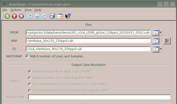
Top of GUI for map2map MATCHMAP example
map2map MATCHMAP example GUI topThe from file is a system LOLA dem. The MAP is an Isis level 2 image. The output file will be a section of the dem extracted out and remapped into the same state as the level 2 image entered as MAP. Because MATCHMAP is checked, all mapping parameters will be determined from MAP, and any listed in the GUI are grayed out.
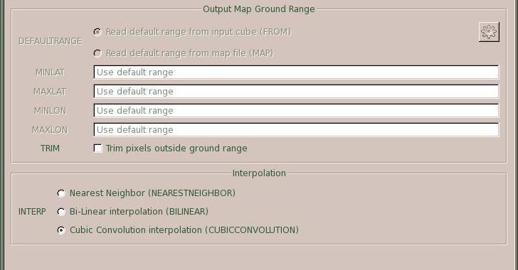
Middle of GUI for map2map MATCHMAP example
map2map MATCHMAP example GUI topThis is the middle of the GUI for the map2map MATCHMAP example. It shows everything grayed out in the output map ground range box because MATCHMAP was checked in the previous image. The default INTERP is selected.
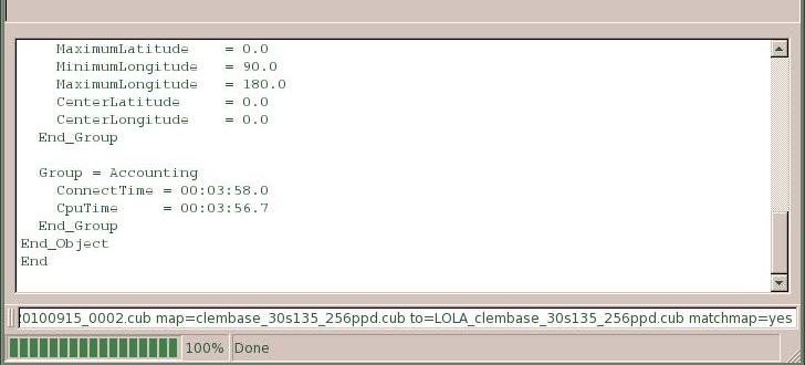
Bottom of GUI for map2map MATCHMAP example
map2map MATCHMAP example GUI topThis is the bottom of the GUI for the map2map MATCHMAP example. It shows the state of the GUI when the application has completed.
Input Images
FROM for map2map MATCHMAP example
Input image (dem) to be reprojected
Parameter Name:
FROM
This is a LOLA global dem stored in the Isis system. A section of this file matching the coverage of MAP will be extracted and reprojected to match MAP.
MAP for map2map MATCHMAP example
Isis level 2 MAP
Parameter Name:
MAP
This is a base tile from the PDS Clementine 750.
Output Image
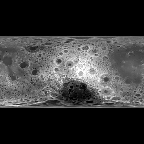
TO for map2map MATCHMAP example
MATCHMAP example TO
Parameter Name:
TO
This is a section of the LOLA global dem extracted and remapped to match a base tile of the PDS Clementine 750. Notice how the geometry matches the geometry of the second input image above (MAP).
Example 2
map2map example demonstrating projection change, resolution change, and use of TRIM
Command Line
map2map
          map2map from=MessengerFlyby_Mariner10_blobal.cub map=npola.map
          to=MessengerFlyby_Mariner10_north_polar.cub pixres=map defaultrange=map
          trim=yes
GUI Screenshot
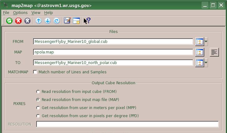
Top of GUI for map2map TRIM example
map2map MATCHMAP example GUI topThe FROM file is a Messenger/Mariner10 global Equirectangular mosaic. The MAP file defines a PolarStereographic projection. The TO file will be the polar section of the FROM extracted out and transformed into a PolarStereographic projection. Notice that PIXRES specifies that the resolution is to be read from the MAP. If the pixel resolution is missing from the map file, the application will throw an error.
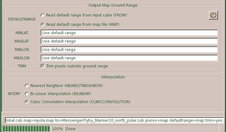
Bottom of GUI for map2map TRIM example
map2map MATCHMAP example GUI topThis is the bottom of the GUI for the map2map TRIM example. It shows that the default map ground range will be read from the MAP. If the ranges are not in MAP, the application will throw an error. Also notice that the TRIM option has been selected.
Input Image

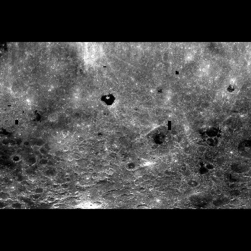
FROM for map2map TRIM example
Input image (dem) to be reprojected
Parameter Name:
FROM
This is a Messenger/Mariner10 global mosaice in an Equirectangular map projection. The north polar section of this file will be extracted and transformed to a Polar Stereographic projection and trimmed to the exact lat/lon range specified in the map file, forming a circle.
Data File
Links open in a new window.| View PVL mapping file | The is the mapping file that defines the output map projection. Since the default range is set to MAP as well, it also contains the desired lat/lon range of the output level 2 image. |
|---|
Output Image
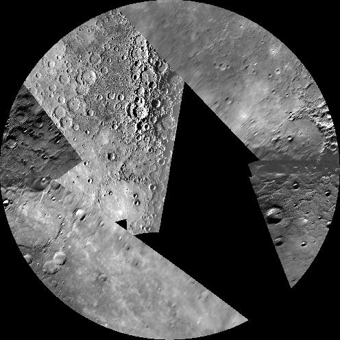
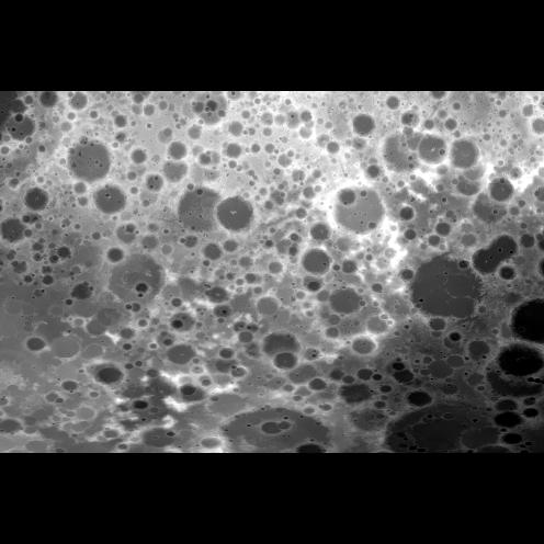
TO for map2map TRIM example
Output PolarStereographic projection of north pole
Parameter Name:
TO
This is the north polar section of the Messenger/Mariner10 global mosaic of Mercury in an Polar Stereographic projection and trimmed to the exact lat/lon range specified in the map file to form a circle.