

seedgrid
Creates a control network for a Lat/Lon range
This program creates a control network for a latitude/longitude range on a specified target planet. The control network that is created is a grid of evenly-spaced control points. The control network generated will have no control measures, but will instead have a known latitude and longitude for each control point. The resulting control network can then have images added to it by using the cnetadd application.
Categories
History
| Stacy Alley | 2009-07-27 | Original version |
| Travis Addair | 2009-08-27 | Fixed error when calculating X/Y range and added application test. |
| Travis Addair | 2009-09-11 | Added parameter allowing user to enter in projection type to use in seeding process. |
| Travis Addair | 2009-09-14 | Changed means of entering projection type to be a map file so as to allow for more customization and accepted projection types. |
| Travis Addair | 2009-09-24 | Added option to use lat/lon spacing when seeding points; fixed bug causing points to be seeded outside the lat/lon range; added a default projection type and reinstated the TARGET parameter so the user does not need to edit a projection file in order to run the program. |
| Travis Addair | 2010-06-07 | Added progress bar. |
| Tracie Sucharski | 2010-10-26 | Changed for new Control Network format. |
| Travis Addair | 2011-04-11 | Changed parameters PROJECTION to MAP and TO to ONET for consistency. |
| Travis Addair | 2011-07-08 | Added error checking for latitude and longitude ranges |
| Jai Rideout | 2011-09-30 | Updated documentation with Janet Richie and Laszlo Kestay for release and added example. |
| Debbie A. Cook | 2012-12-10 | Changed to use TProjection instead of Projection. References #775 |
| Jeannie Backer | 2016-04-22 | Cleaned up duplicate code. Added error message to alert to the user when the program fails to find TargetRadii. Added errors appTest. References #3892 |
| Jesse Mapel | 2018-07-06 | Changed to get the target radii directly from the Target class instead of the control network because the control network no longer has them. Fixes #5457. |
Parameters
Target/Range
| Type | string |
|---|---|
| Internal Default | From MAP file |
| Type | filename |
|---|---|
| File Mode | input |
| Default Path | $ISISROOT/appdata/templates/maps |
| Default | $ISISROOT/appdata/templates/maps/sinusoidal.map |
| Filter | *.map *.cub |
| Type | double |
|---|
| Type | double |
|---|
| Type | double |
|---|
| Type | double |
|---|
Step Size
| Type | string | |||||||||
|---|---|---|---|---|---|---|---|---|---|---|
| Default | METER | |||||||||
| Option List: |
|
| Type | double |
|---|
| Type | double |
|---|
| Type | double |
|---|
| Type | double |
|---|
Control
| Type | string |
|---|---|
| Internal Default | No Id |
| Type | string |
|---|
| Type | string |
|---|---|
| Internal Default | No Description |
Files
| Type | filename |
|---|---|
| File Mode | output |
Example 1
Seeding Mars
Command Line
seedgrid
          TARGET=mars LATSTEP=20 LONSTEP=20 MINLAT=-90 MAXLAT=90 MINLON=0
          MAXLON=360 ONET=out.net SPACING=latlon POINTID='id????'
Data File
Links open in a new window.| The resulting control network | This is the control network that is created by seedgrid. |
|---|
Output Image
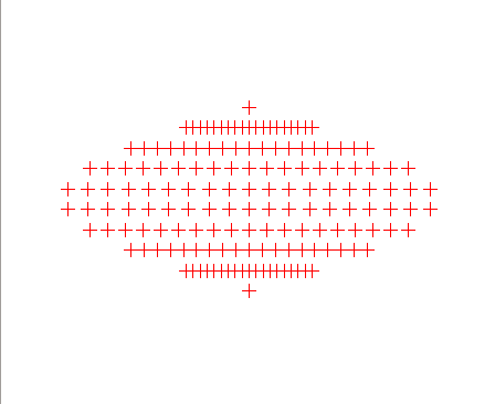
Point Distribution Visualization
Resulting distribution of points in the networkThis image is a visualization of the point distribution within the control network. This is projected using a sinusoidal projection. Please note that this image is not an output of the seedgrid application. It is included as a visual aid only.