

shade
Create shaded-relief cube from topographic cube
This program will create a shaded-relief cube from a topographic cube. It uses the sun angle (azimuth)
as well as the solar elevation (zenith) to compute the correct shading on the output cube.
Categories
History
| Tracie Sucharski | 2003-01-09 | Original version |
| Tracie Sucharski | 2003-01-28 | Changed category from filter to photometry. |
| Tracie Sucharski | 2003-02-07 | Changed user parameter names and now read pixel resolution from labels. |
| Kim Sides | 2003-05-13 | Added application test |
| Stuart Sides | 2003-05-16 | Modified schema location from astogeology... to isis.astrogeology..." |
| Stuart Sides | 2003-07-29 | Modified filename parameters to be cube parameters where necessary |
| Brian Peck | 2006-12-25 | Algorithm change and input parameter change. |
| Mackenzie Boyd | 2010-01-06 | Reversed slopes to be correct. Changed azimuth to be 0 degrees is 12 o'clock rotating clockwise. Updated documentation to match. |
| Steven Lambright | 2012-11-19 | Abstracted out the hillshade algorithm (the algorithm that computes the resulting values from this program) into it's own class. This program's code has changed to utilize the new class, but the functionality should be unchanged. References #1232. |
Parameters
Files
Use this parameter to select the input filename. All bands within the file
will have the shade applied.
| Type | cube |
|---|---|
| File Mode | input |
| Filter | *.cub |
This file will contain the shaded output image.
| Type | cube |
|---|---|
| File Mode | output |
| Pixel Type | real |
Sun Parameters
The direction of sun with 0 degrees at the 12:00, north position,
rotating clockwise. Ranging from 0 to 359.9.
| Type | double |
|---|---|
| Default | 90.0 |
| Minimum | 0 (inclusive) |
| Maximum | 360 (exclusive) |
The Sun Angle is the elevation at which the sun is relative to the
planet horizon. 90 degrees is at the horizon, 0 is directly overhead.
| Type | double |
|---|---|
| Default | 45.0 |
| Minimum | 0 (inclusive) |
| Maximum | 90 (inclusive) |
SCALE PARAMETERS
The pixel resolution of the image. This parameter will default to
the value from the labels or may be used to increase or decrease the
apparent steepness. If no mapping group exists, the user must enter a
pixel resolution. Greater than the image's pixel resolution will level
and smooth, and less than will make steep and sharpen.
| Type | double |
|---|---|
| Internal Default | Automatic |
Example 1
Shading Vallis Marinaris
Creating a shaded relief of Vallis Marinaris with a 22 degree azimuth
and a 45 degree zenith
Command Line
In this example shade will create a shaded relief of Vallis Marinaris
with a 22 solar azimuth and a 45 degree zenith
shade from=vallis_marinaris.cub to=22.cub azimuth=22
GUI Screenshot
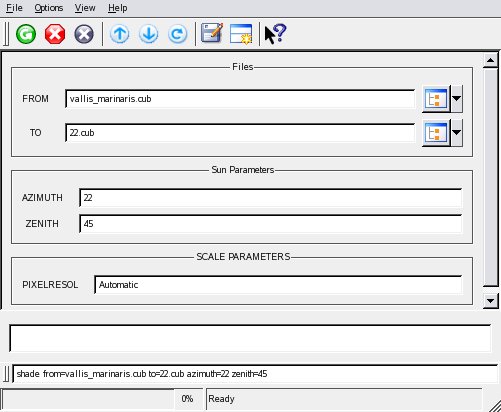
Example Gui
shade GuiScreenshot of the GUI with parameters filled in to perform a 22 azimuth shade on our input image.
Input Image
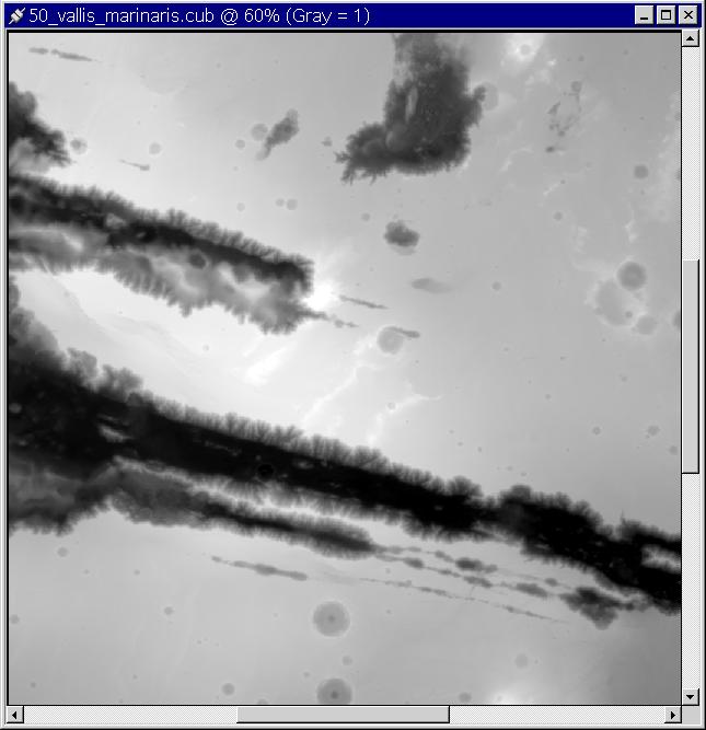
Input image for shade
Input image
Parameter Name:
FROM
This is the input image used in the creation of our shaded relief.
Output Image
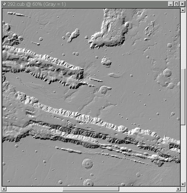
Output image for shade
Output image showing results of the shade application.
Parameter Name:
TO
This is the output image that resulted.