This program imports Mars Express HRSC files. This works by first
determining whether or not the input file has prefix data. If there is
prefix data, the prefix data is collected and used to look for "gaps" - HRSC
files can give us a time and exposure duration for each line, we look for
where the time + exposure duration =/= next line's time. We populate a
table (LineScanTimes) with the prefix data and lineInFile with whether or
not a gap should be inserted. For all files, we now process the data and if
there were gaps, they will be put in their proper places. This is a two-pass
system for files with prefix data, one-pass for files without. The Isis2
equivalent to this program is mex2isis.pl. It is worth noting that
regardless of the input file's byte order, the prefix data byte order is
always LSB.
This program replaces the following
applications
existing in previous versions of ISIS:
mex2isis.pl
readpfx
History
Steven Lambright
2008-01-16
Original version
Christopher Austin
2008-03-18
Checks if input file is rdr based on whether or not the input file has
prefix data.
Steven Lambright
2008-05-13
Removed references to CubeInfo
Steven Lambright
2008-07-28
Updated to support the HRSC camera model. The Kernels group now has the IK code
properly added, the summing keyword is propagated, the times table is now compressed
into only having entries on time changes, and the times no longer have a 'Z' at the end
of them once imported.
Adam Paquette
2016-10-05
Updated the error messages thrown when hrsc2isis trys to ingest an image that is not an HRSC
image, and when hrsc2isis trys to ingest a map projected image. Fixes #4259.
Use this parameter to select the PDS filename. This file
must contain the PDS labels, however the image data can
be detached and will be automatically obtained from the
PDS image pointer keyword. If the pointer is incorrect then
use the IMAGE parameter to specify the file containing the
binary image data.
This is the raw input image, not imported with this program
This image was imported with pds2isis and then exported with isis2std, in order to get a
good idea of what the raw input image looks like.
Output HRSC Gap
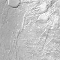
Input discontinuity from this example
This is a zoomed in region of what will become a gap from this example. Notice the
features aren't aligned in the middle of the image, as if there are missing lines.
Output Images
Output HRSC Image
Output image from this example
This is the output from this example. The large "black" areas are NULL lines where data
was missing, according to the prefix data on the raw input image.
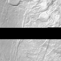
Output HRSC Gap
A gap from this example
This is a zoomed in region of a gap from this example. Notice the features on the top
and bottom would not normally line up if the gap did not exist.