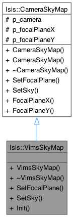
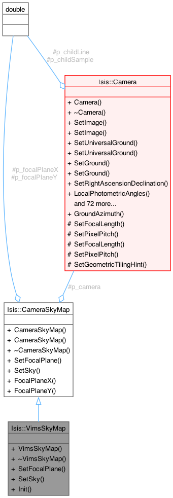
Convert between undistorted focal plane and ground coordinates. More...
#include <VimsSkyMap.h>


Public Member Functions | |
| VimsSkyMap (Camera *parent, Pvl &lab) | |
| Constructs the VimsSkyMap object. | |
| virtual | ~VimsSkyMap () |
| Destroys the VimsSkyMap object. | |
| virtual bool | SetFocalPlane (const double ux, const double uy, const double uz) |
| Compute ground position from focal plane coordinate. | |
| virtual bool | SetSky (const double ra, const double dec) |
| Sets the sky position to the given ra and dec. | |
| void | Init (Pvl &lab) |
| Initialize vims sky model. | |
| double | FocalPlaneX () const |
| double | FocalPlaneY () const |
Protected Attributes | |
| Camera * | p_camera |
| The main camera to calculate distortions on. | |
| double | p_focalPlaneX |
| Undistorted x value for the focal plane. | |
| double | p_focalPlaneY |
| Undistorted y value for the focal plane. | |
Convert between undistorted focal plane and ground coordinates.
This base class is used to convert between undistorted focal plane coordinates (x/y) in millimeters and ground coordinates lat/lon. This class handles the case of framing cameras.
Constructs the VimsSkyMap object.
References Isis::CameraSkyMap::CameraSkyMap().
|
inlinevirtual |
Destroys the VimsSkyMap object.
|
inlineinherited |
References p_focalPlaneX.
|
inlineinherited |
References p_focalPlaneY.
| void Isis::VimsSkyMap::Init | ( | Pvl & | lab | ) |
Initialize vims sky model.
| iException::Io | - "Cannot process NYQUIST(undersampled) mode " |
| iException::Io | - "Can't open unit vector file" |
References _FILEINFO_, Isis::PvlObject::findGroup(), Isis::NULL8, Isis::CameraSkyMap::p_camera, Isis::IException::Programmer, Isis::toDouble(), and Isis::PvlObject::Traverse.
|
virtual |
Compute ground position from focal plane coordinate.
This method will compute the ground position given an undistorted focal plane coordinate. Note that the latitude/longitude value can be obtained from the camera class passed into the constructor.
| ux | distorted focal plane x in millimeters |
| uy | distorted focal plane y in millimeters |
| uz | distorted focal plane z in millimeters |
Reimplemented from Isis::CameraSkyMap.
References Isis::CameraSkyMap::p_camera.
|
virtual |
Sets the sky position to the given ra and dec.
| ra | the right ascension |
| dec | the declination |
Reimplemented from Isis::CameraSkyMap.
References Isis::LeastSquares::AddKnown(), Isis::LeastSquares::Evaluate(), Isis::LeastSquares::Knowns(), Isis::NULL8, Isis::CameraSkyMap::p_camera, Isis::CameraSkyMap::p_focalPlaneX, Isis::CameraSkyMap::p_focalPlaneY, and Isis::LeastSquares::Solve().
|
protectedinherited |
The main camera to calculate distortions on.
Referenced by CameraSkyMap(), Isis::CSMSkyMap::CSMSkyMap(), Isis::VimsSkyMap::Init(), SetFocalPlane(), Isis::VimsSkyMap::SetFocalPlane(), SetSky(), Isis::CSMSkyMap::SetSky(), Isis::LineScanCameraSkyMap::SetSky(), and Isis::VimsSkyMap::SetSky().
|
protectedinherited |
Undistorted x value for the focal plane.
Referenced by FocalPlaneX(), SetSky(), Isis::CSMSkyMap::SetSky(), Isis::LineScanCameraSkyMap::SetSky(), and Isis::VimsSkyMap::SetSky().
|
protectedinherited |
Undistorted y value for the focal plane.
Referenced by FocalPlaneY(), SetSky(), Isis::CSMSkyMap::SetSky(), Isis::LineScanCameraSkyMap::SetSky(), and Isis::VimsSkyMap::SetSky().