|
| | PolarStereographic (Pvl &label, bool allowDefaults=false) |
| | Constructs a PolarStereographic object.
|
| |
| | ~PolarStereographic () |
| | Destroys the PolarStereographic object.
|
| |
| bool | operator== (const Projection &proj) |
| | Compares two Projection objects to see if they are equal.
|
| |
| QString | Name () const |
| | Returns the name of the map projection, "PolarStereographic".
|
| |
| QString | Version () const |
| | Returns the version of the map projection.
|
| |
| double | TrueScaleLatitude () const |
| | Returns the latitude of true scale.
|
| |
| bool | SetGround (const double lat, const double lon) |
| | This method is used to set the latitude/longitude (assumed to be of the correct LatitudeType, LongitudeDirection, and LongitudeDomain.
|
| |
| bool | SetCoordinate (const double x, const double y) |
| | This method is used to set the projection x/y.
|
| |
| bool | XYRange (double &minX, double &maxX, double &minY, double &maxY) |
| | This method is used to determine the x/y range which completely covers the area of interest specified by the lat/lon range.
|
| |
| PvlGroup | Mapping () |
| | This function returns the keywords that this projection uses.
|
| |
| PvlGroup | MappingLatitudes () |
| | This function returns the latitude keywords that this projection uses.
|
| |
| PvlGroup | MappingLongitudes () |
| | This function returns the longitude keywords that this projection uses.
|
| |
| double | EquatorialRadius () const |
| | This returns the equatorial radius of the target.
|
| |
| double | PolarRadius () const |
| | This returns the polar radius of the target.
|
| |
| double | Eccentricity () const |
| | This returns the eccentricity of the target,.
|
| |
| double | LocalRadius (double lat) const |
| | This method returns the local radius in meters at the specified latitude position.
|
| |
| double | LocalRadius () const |
| | This method returns the local radius in meters at the current latitude position.
|
| |
| virtual bool | IsEquatorialCylindrical () |
| | This method returns true if the projection is equatorial cylindrical.
|
| |
| bool | IsPlanetocentric () const |
| | This indicates if the latitude type is planetocentric (as opposed to planetographic).
|
| |
| bool | IsPlanetographic () const |
| | This indicates if the latitude type is planetographic (as opposed to planetocentric).
|
| |
| QString | LatitudeTypeString () const |
| | This method returns the latitude type as a string.
|
| |
| double | ToPlanetocentric (const double lat) const |
| | This method converts a planetographic latitude to a planetocentric latitude.
|
| |
| double | ToPlanetographic (const double lat) const |
| | This method converts a planetocentric latitude to a planetographic latitude.
|
| |
| bool | IsPositiveEast () const |
| | This indicates if the longitude direction type is positive west (as opposed to postive east).
|
| |
| bool | IsPositiveWest () const |
| | This indicates if the longitude direction type is positive east (as opposed to postive west).
|
| |
| QString | LongitudeDirectionString () const |
| | This method returns the longitude direction as a string.
|
| |
| bool | Has180Domain () const |
| | This indicates if the longitude domain is -180 to 180 (as opposed to 0 to 360).
|
| |
| bool | Has360Domain () const |
| | This indicates if the longitude domain is 0 to 360 (as opposed to -180 to 180).
|
| |
| QString | LongitudeDomainString () const |
| | This method returns the longitude domain as a string.
|
| |
| virtual double | MinimumLatitude () const |
| | This returns the minimum latitude of the area of interest.
|
| |
| virtual double | MaximumLatitude () const |
| | This returns the maximum latitude of the area of interest.
|
| |
| virtual double | MinimumLongitude () const |
| | This returns the minimum longitude of the area of interest.
|
| |
| virtual double | MaximumLongitude () const |
| | This returns the maximum longitude of the area of interest.
|
| |
| virtual double | Latitude () const |
| | This returns a latitude with correct latitude type as specified in the label object.
|
| |
| virtual double | Longitude () const |
| | This returns a longitude with correct longitude direction and domain as specified in the label object.
|
| |
| virtual bool | SetUniversalGround (const double lat, const double lon) |
| | This method is used to set the latitude/longitude which must be Planetocentric (latitude) and PositiveEast/Domain360 (longitude).
|
| |
| bool | SetUnboundUniversalGround (const double coord1, const double coord2) |
| | This method is used to set the latitude/longitude.
|
| |
| virtual double | UniversalLatitude () |
| | This returns a universal latitude (planetocentric).
|
| |
| virtual double | UniversalLongitude () |
| | This returns a universal longitude (positive east in 0 to 360 domain).
|
| |
| double | Scale () const |
| | This method returns the scale for mapping world coordinates into projection coordinates.
|
| |
| bool | operator!= (const Projection &proj) |
| | This method determines whether two map projection objects are not equal.
|
| |
| void | setProjectionType (const ProjectionType ptype) |
| | Sets the projection subclass type.
|
| |
| ProjectionType | projectionType () const |
| | Returns an enum value for the projection type.
|
| |
| bool | IsSky () const |
| | Returns true if projection is sky and false if it is land.
|
| |
| virtual bool | HasGroundRange () const |
| | This indicates if the longitude direction type is positive west (as opposed to postive east).
|
| |
| double | Rotation () const |
| | Returns the value of the Rotation keyword from the mapping group.
|
| |
| void | SetWorldMapper (WorldMapper *mapper) |
| | If desired the programmer can use this method to set a world mapper to be used in the SetWorld, WorldX, and WorldY methods.
|
| |
| bool | IsGood () const |
| | This indicates if the last invocation of SetGround, SetCoordinate, SetUniversalGround, or SetWorld was with successful or not.
|
| |
| double | XCoord () const |
| | This returns the projection X provided SetGround, SetCoordinate, SetUniversalGround, or SetWorld returned with success.
|
| |
| double | YCoord () const |
| | This returns the projection Y provided SetGround, SetCoordinate, SetUniversalGround, or SetWorld returned with success.
|
| |
| virtual bool | SetWorld (const double x, const double y) |
| | This method is used to set a world coordinate.
|
| |
| virtual double | WorldX () const |
| | This returns the world X coordinate provided SetGround, SetCoordinate, SetUniversalGround, or SetWorld returned with success.
|
| |
| virtual double | WorldY () const |
| | This returns the world Y coordinate provided SetGround, SetCoordinate, SetUniversalGround, or SetWorld returned with success.
|
| |
| double | ToWorldX (const double projectionX) const |
| | This method converts a projection x value to a world x value.
|
| |
| double | ToWorldY (const double projectionY) const |
| | This method converts a projection y value to a world y value.
|
| |
| double | ToProjectionX (const double worldX) const |
| | This method converts a world x value to a projection x value.
|
| |
| double | ToProjectionY (const double worldY) const |
| | This method converts a world y value to a projection y value.
|
| |
| double | Resolution () const |
| | This method returns the resolution for mapping world coordinates into projection coordinates.
|
| |
| void | SetUpperLeftCorner (const Displacement &x, const Displacement &y) |
| | This method is used to find the XY range for oblique aspect projections (non-polar projections) by "walking" around each of the min/max lat/lon.
|
| |
|
| void | XYRangeCheck (const double latitude, const double longitude) |
| | This convience function is established to assist in the development of the XYRange virtual method.
|
| |
| bool | inLongitudeRange (double longitude) |
| | Determine whether the given longitude is within the range of the MinimumLongitude and MaximumLongitude range of this projection.
|
| |
| bool | inLongitudeRange (double minLon, double maxLon, double longitude) |
| | Determine whether the given longitude is within the range of the given min and max longitudes.
|
| |
| bool | inLatitudeRange (double latitude) |
| | Determine whether the given latitude is within the range of the MinimumLatitude and MaximumLatitude range of this projection.
|
| |
| bool | xyRangeOblique (double &minX, double &maxX, double &minY, double &maxY) |
| | This method is used to find the XY range for oblique aspect projections (non-polar projections) by "walking" around each of the min/max lat/lon.
|
| |
| double | qCompute (const double sinPhi) const |
| | A convience method to compute Snyder's q equation (3-12) for a given latitude, \(\phi\).
|
| |
| double | phi2Compute (const double t) const |
| | A convience method to compute latitude angle phi2 given small t, from Syder's recursive equation (7-9)
|
| |
| double | mCompute (const double sinphi, const double cosphi) const |
| | A convience method to compute Snyder's m equation (14-15) for a given latitude, \(\phi\).
|
| |
| double | tCompute (const double phi, const double sinphi) const |
| | A convience method to compute Snyder's t equation (15-9) for a given latitude, \(\phi\).
|
| |
| double | e4Compute () const |
| | A convience method to compute.
|
| |
| void | SetXY (double x, double y) |
| | This protected method is a helper for derived classes.
|
| |
| void | SetComputedXY (double x, double y) |
| | This protected method is a helper for derived classes.
|
| |
| double | GetX () const |
| | Calculates the unrotated form of current x value.
|
| |
| double | GetY () const |
| | Calculates the unrotated form of the current y value.
|
| |
| double | PixelResolution () const |
| | Returns the pixel resolution value from the PVL mapping group in meters/pixel.
|
| |
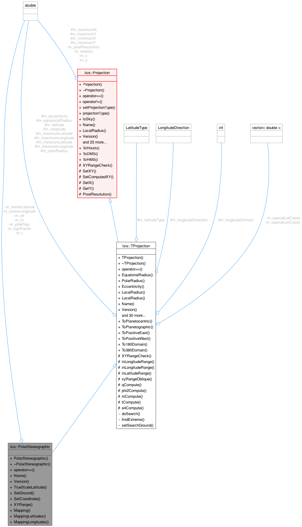
Stereographic Map Projection for Polar Aspect.
This class provides methods for the forward and inverse equations of a Polar Stereographic map projection (for an ellipsoid).
The Stereographic projection is used for polar aspect maps. This projection is azimuthal, conformal, and maps onto a plane. The center longitude is a straight line. All other longitudes are represented by arcs of circles. The antipodal point can not be projected.
The code was converted to C++ from the Fortran version of the USGS General Cartographic Transformation Package (GCTP). This class inherits Projection and provides the two virtual methods SetGround (forward) and SetCoordinate (inverse) and a third virtual method, XYRange, for obtaining projection coordinate coverage for a latitude/longitude window.
Please see the Projection class for a full accounting of all the methods available.
- Author
- 2004-02-24 Jeff Anderson
- History
2004-02-24 Jeff Anderson - Fixed a bug in TrueScaleLatitude and changed default computation for CenterLatitude
2005-03-01 Elizabeth Ribelin - Modified file to support Doxygen documentation
2005-03-11 Elizabeth Ribelin - added TrueScaleLatitude method test to unitTest
2006-06-14 Elizabeth Miller - Added error check to make sure the center latitude is not zero
2007-06-29 Steven Lambright - Added Mapping, MappingLatitudes and MappingLongitudes methods.
2008-05-09 Steven Lambright - Added Name, Version methods
2012-06-15 Jeannie Backer - Added documentation. Added forward declaration of Pvl, PvlGroup to header file. Ordered includes in implementation file. Moved Name, Version, and TrueScaleLatitude to the implementation file. Minor modifications to comply with some coding standards. References #928.
2012-08-01 Kimberly Oyama and Steven Lambright - Modified SetGround() so that it returns false when the lat parameter is the pole opposite of the center latitude. Also updated the unit tests to exercise this change. References #604.
2012-01-20 Debbie A. Cook - Changed to use TProjection instead of Projection. References #775.
Definition at line 64 of file PolarStereographic.h.
This method is used to find the XY range for oblique aspect projections (non-polar projections) by "walking" around each of the min/max lat/lon.
- Parameters
-
| minX | Minimum x projection coordinate which covers the latitude longitude range specified in the labels. |
| maxX | Maximum x projection coordinate which covers the latitude longitude range specified in the labels. |
| minY | Minimum y projection coordinate which covers the latitude longitude range specified in the labels. |
| maxY | Maximum y projection coordinate which covers the latitude longitude range specified in the labels. |
- Returns
- bool Indicates whether the method was successful.
- See also
- XYRange()
- Author
- Stephen Lambright
@history 2011-07-02 Jeannie Backer - Moved this code from ObliqueCylindrical class to its own method here. This method searches for extreme (min/max/discontinuity) coordinate values along the constBorder line between minBorder and maxBorder (that is, across latitudes/longitudes). This method locates the extrema by utilizing the findExtreme() method until the coordinate values converge. Then, extremeVal parameter is updated with this value before returning.
Discontinuities are stored in m_specialLatCases and m_specialLonCases so they may be checked again later, which creates significantly more accuracy in some cases.
- Parameters
-
| minBorder | Minimum latitude or longitude to search between. |
| maxBorder | Maximum latitude or longitude to search between. |
| extremeVal | The resulting global coordinate value (min or max value for x or y, depending on findMin and searchX) on the constBorder. |
| constBorder | The latitude or longitude that remains constant. The method will step along this border. |
| searchX | Indicates whether the method is searching for a min or max x-coordinate. If false the method searches for min or max y-coordinate. |
| searchLongitude | Indicates whether the method will search along a longitude. If true, constBorder is longitude and all other borders are latitudes. If false, the method searches a latitude (constBorder is a lat, other borders lons). |
| findMin | Indicates whether the method is looking for a minimum coordinate value. If false, the method is looking for a maximum value. |
- Author
- Steven Lambright
- History
- 2011-07-02 Jeannie Backer - Moved this code from ObliqueCylindrical class to its own method here. Added condition to do-while loop for more precision. Replaced hard-coded TOLERANCE with 1/2 pixel resolution. (Defaults to 0.5)
Searches for extreme (min/max/discontinuity) coordinate values across latitudes/longitudes.
This method looks for these extrema along the constBorder between minBorder and maxBorder by stepping along constBorder (10 times) from the minBorder and maxBorder. Then, the range of this extreme value is recorded in minBorder and maxBorder and the coordinate values corresponding to these new borders are stored in minBorderX, minBorderY, maxBorderX and maxBorderY.
This function should be used by calling it repeatedly until minBorderX and minBorderY do not equal maxBorderX and maxBorderY, respectively. Discontinuities will cause the minBorderX, minBorderY, maxBorderX and maxBorderY to never converge. If minBorderX never comes close to maxBorderX or minBorderY never comes close to maxBorderY, then between minBorder and maxBorder is the value of the most extreme value. In this case, either the smaller or larger of the x or y values found will be correct, depending on the values of findMin and searchX.
- Parameters
-
| minBorder | Minimum latitude or longitude to search between. This value gets updated to a more precise range. |
| maxBorder | Maximum latitude or longitude to search between. This value gets updated to a more precise range. |
| minBorderX | The x-value corresponding to the lower resultant minBorder and the constBorder, which is more accurate when nearly equal to maxBorderX. |
| minBorderY | The y-value corresponding to the lower resultant minBorder and the constBorder, which is more accurate when nearly equal to maxBorderY. |
| maxBorderX | The x-value corresponding to the higher resultant maxBorder and the constBorder, which is more accurate when nearly equal to minBorderX. |
| maxBorderY | The y-value corresponding to the higher resultant maxBorder and the constBorder, which is more accurate when nearly equal to minBorderY. |
| constBorder | The latitude or longitude that remains constant. The method will step along this border. |
| searchX | Indicates whether the method is searching for a min or max x-coordinate. If false the method searches for min or max y-coordinate. |
| searchLongitude | Indicates whether the method will search along a longitude. If true, constBorder is longitude and all other borders are latitudes. If false, the method searches a latitude (constBorder is a lat, other borders lons). |
| findMin | Indicates whether the method is looking for a minimum coordinate value. If false, the method is looking for a maximum value. |
- Author
- Stephen Lambright
- History
- 2011-07-02 Jeannie Backer - Moved this code from ObliqueCylindrical class to its own method here. Replaced parameters minVal and maxVal with minBorderX, minBorderY, maxBorderX, and maxBorderY.
This function sets the ground for the given border values. It calls the SetGround(lat, lon) method with the appropriate lat/lon values, depending on whether variableIsLat is true.
This method is used by doSearch and findExtreme in order to set the ground correctly each time.
- Parameters
-
| variableBorder | The latitude or longitude that is variable in the search methods. |
| constBorder | The latitude or longitude that is constant in the search methods. |
| variableIsLat | Indicates whether variableBorder is the latittude value and constBorder is the longitude value. If false, variableBorder is the longitude value and constBorder is the latitude value. |
- Author
- Stephen Lambright
- History
- 2011-07-02 Jeannie Backer - Moved this code from ObliqueCylindrical class to its own method here. Added error.
This method sets the UpperLeftCornerX and UpperLeftCornerY keywords in the projection mapping group, in meters.
- Parameters
-
| x | the upper left corner x value |
| y | the upper left corner y value |
Definition at line 1373 of file Projection.cpp.
References m_mappingGrp, Isis::Displacement::meters(), and Isis::toString().
Referenced by Isis::ProjectionFactory::CreateForCube(), Isis::ProjectionFactory::CreateForCube(), Isis::ProjectionFactory::CreateFromCube(), Isis::ProjectionFactory::RingsCreateForCube(), Isis::ProjectionFactory::RingsCreateForCube(), Isis::ProjectionFactory::RingsCreateFromCube(), and Isis::ProcessMapMosaic::SetOutputCube().