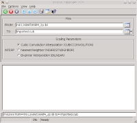
This program will import raw images, acquired from the Near Earth Asteroid
Rendezvous - Shoemaker (NEAR Shoemaker) mission's Multispectral Imager
(MSI) instrument, to ISIS data file format.
The raw image must be in FITS (Flexible Image Transport) format and
have a PDS label file that points to the location of the FITS image. You must input either the label file or the FITS file for the "TO" input
parameter. Projected images are not supported. Please note if the FITS file is given, the label file must
exist in the same directory or the program will throw an error.
This program will verify that the input files are valid by checking the
following label keyword values. An error will be thrown if any of these
criteria are not met.
INSTRUMENT_ID = MSI
LINE_SAMPLES = 537
LINES = 244
SAMPLE_DISPLAY_DIRECTION = RIGHT
LINE_DISPLAY_DIRECTION = UP
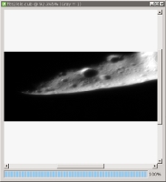
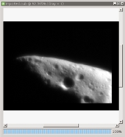
The output cube- successfully imported into ISIS goes through the following processes:
Convert the raw FITS image data to an ISIS cube.
Save the labels from the input PDS label file to the output ISIS cube. Note that FITS labels are not transferred.
Enlarge the image from 537 samples x 244 lines to 537 x 412 using the user-specified interpolation algorithm. Defaults to cubic convolution.
Flip the image vertically, i.e. across the horizontal axis.
Trim 33 pixels from the top, bottom, left and right sides. These
pixels along the borders will be set to nulls.
Name of the input NEAR MSI image file to be imported into ISIS
format. You may enter the label or the image file. If the image
file is given, the program will search in the same directory for a
label file with the same base name as the image file base name.