Home

User Documentation

Getting Started
Learn More
Explore in Detail
Get Inspired

Contributor Documentation

Getting Started
Learn More
Explore in Detail
Get Inspired

Quick Links

Software Manual
AstroDiscuss
GitHub
API Reference

Documentation Versions


ISIS 2

Documentation
Tutorials
Technical Documents
USGS

ISIS Application Documentation


shade

Printer Friendly View | TOC | Home

Create shaded-relief cube from topographic cube

Overview Parameters Example 1

Description

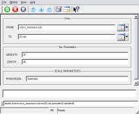
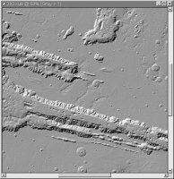
This program will create a shaded-relief cube from a topographic cube. It uses the sun angle (azimuth) as well as the solar elevation (zenith) to compute the correct shading on the output cube.

Categories


History

Tracie Sucharski2003-01-09 Original version
Tracie Sucharski2003-01-28 Changed category from filter to photometry.
Tracie Sucharski2003-02-07 Changed user parameter names and now read pixel resolution from labels.
Kim Sides2003-05-13 Added application test
Stuart Sides2003-05-16 Modified schema location from astogeology... to isis.astrogeology..."
Stuart Sides2003-07-29 Modified filename parameters to be cube parameters where necessary
Brian Peck2006-12-25 Algorithm change and input parameter change.
Mackenzie Boyd2010-01-06 Reversed slopes to be correct. Changed azimuth to be 0 degrees is 12 o'clock rotating clockwise. Updated documentation to match.
Steven Lambright2012-11-19 Abstracted out the hillshade algorithm (the algorithm that computes the resulting values from this program) into it's own class. This program's code has changed to utilize the new class, but the functionality should be unchanged. References #1232.

Parameter Groups

Files

Name Description
FROM Input cube
TO Output cube

Sun Parameters

Name Description
AZIMUTHSun azimuth
ZENITHSun angle

SCALE PARAMETERS

Name Description
PIXELRESOLPixel resolution
X

Files: FROM


Description

Use this parameter to select the input filename. All bands within the file will have the shade applied.

Type cube
File Mode input
Filter *.cub
Close Window
X

Files: TO


Description

This file will contain the shaded output image.

Type cube
File Mode output
Pixel Type real
Close Window
X

Sun Parameters: AZIMUTH


Description

The direction of sun with 0 degrees at the 12:00, north position, rotating clockwise. Ranging from 0 to 359.9.

Type double
Default 90.0
Minimum 0 (inclusive)
Maximum 360 (exclusive)
Close Window
X

Sun Parameters: ZENITH


Description

The Sun Angle is the elevation at which the sun is relative to the planet horizon. 90 degrees is at the horizon, 0 is directly overhead.

Type double
Default 45.0
Minimum 0 (inclusive)
Maximum 90 (inclusive)
Close Window
X

SCALE PARAMETERS: PIXELRESOL


Description

The pixel resolution of the image. This parameter will default to the value from the labels or may be used to increase or decrease the apparent steepness. If no mapping group exists, the user must enter a pixel resolution. Greater than the image's pixel resolution will level and smooth, and less than will make steep and sharpen.

Type double
Internal Default Automatic
Close Window

Example 1

Shading Vallis Marinaris

Description

Creating a shaded relief of Vallis Marinaris with a 22 degree azimuth and a 45 degree zenith

Command Line

shade from=vallis_marinaris.cub to=22.cub azimuth=22
In this example shade will create a shaded relief of Vallis Marinaris with a 22 solar azimuth and a 45 degree zenith

GUI Screenshot

shade Gui

Example Gui

Screenshot of the GUI with parameters filled in to perform a 22 azimuth shade on our input image.

Input Image

Input image

Input image for shade

Parameter Name: FROM

This is the input image used in the creation of our shaded relief.

Output Image

Output image showing results of the shade application.

Output image for shade

Parameter Name: TO

This is the output image that resulted.