Runs a Themis cube through the processing for levels 0 and/or 2
Overview
Parameters
Example 1
Description
Runs Mars Odyssey Themis images through the applications necessary to create a
map projected product. There are two stages of processing, ingestion and mapping
(radiometric calibration is assumed as Themis RDRs are available). Each stage can
be disabled and runs all the programs necessary to complete that stage if
not disabled.
All intermediate files will be generated in the users Isis temporary
directory and deleted after they are no longer needed. In case of a catastrophic
failure the intermediate files should be deleted. Their names will be the
name of the application appended to the original file name followed by a
6 digit unique number.
Added Bands parameter and utilized IsisProcessExecutable class
Elizabeth Miller
2005-12-08
Fixed bug in output file naming
Elizabeth Miller
2005-12-15
Modified to output number of bands specified even when just doing ingestion
Elizabeth Miller
2006-05-18
Modified UI and parameters to be consistent with changes made to spiceinit
Elizabeth Miller
2006-07-25
Removed the AUTOLON parameter (no longer a parameter in cam2map)
Elizabeth Miller
2006-09-08
Added support for the themisVis camera model
Brendan george
2006-09-26
Documentation fixes
Elizabeth Miller
2006-09-26
Fixed bug in PIXRES use caused by changes in cam2map
Steven Lambright
2007-11-06
Added CKNADIR parameter for spiceinit.
Steven Lambright
2008-06-13
Updated to use new themis vis functionality. Instead of the themis images
being split into a framelet per cube, they are now split into even and odd
cubes.
Steven Lambright
2008-07-16
Updated to guarantee vis images have matching mapping groups, changed
tempory file naming conventions, enabled thmvistrim on rdr files.
Steven Lambright
2008-07-24
Updated to fix problem with BANDS parameter. Before, the bands option
would sometimes cause an error incorrectly. Also fixed a case where the
input file would be deleted.
Steven Lambright
2008-07-28
Updated to fix problem with BANDS parameter with IR images. This parameter had
a chance to not take effect.
Steven Lambright
2008-08-04
Updated to use new pipeline class.
Jeannie Backer
2014-08-22
Updated vis test truth data for the RDR cube due to a modified in the THEMIS VIS distortion
map. Added vis test for EDR data with MAPPING=true. Added error test. Improved test coverage
to 95/98/100%. References #1659.
Jeffrey Covington
2015-01-27
Removed unreachable code.
Makayla Shepherd and Andrew Stebenne
2015-07-14
Updated to fix a crash that occurs when invalid files are passed in as parameters.
Fixes #1025.
Input filename. This file can be in one of two stages. A raw PDS Themis RDR or
an ISIS Level 0/1 cube. The level 0/1 cube is assumed to have been run
through thm2isis and spiceinit.
Output filename from the last enabled processing sequence. By
default the filename will be generated from the input filename with
".lev#" appended to the name, where "#" is the last level of
processing (i.e., INGESTION = "lev1" or MAPPING = "lev2").
For ThemisVIS images, if processing is stopped at the ingestion
phase, there will be an output cube for each frame in the image,
with a ".frame#" appended to the end of the filename.
This parameter allows the user to specify a sub-set of
bands to process. Enter bands separated by commas (no spaces
allowed). For example, 1,3,8 or 1-3,9 or 5
ISIS camera models can use a shape model (a projected ISIS cube that defines the radii for a global or regional area). You can choose
to select a shape model or to use the definition of the ellipsoid found in the planetary constants (PCK) file.
Type
string
Default
SYSTEM
Option List:
Option
Brief
Description
ELLIPSOID
Use triiaxial ellipsoid from PCK
The camera will use the radii defined in the planetary constants file (PCK) when
determining intersections of the body surface
Exclusions
MODEL
SYSTEM
Search system for a default shape model
This option will search the default system data area ($ISISDATA/base/dems) for a shape model that
matches the target of the input cube. If none are found then no shape model will be used and the default
ellipsoid parameters found in the planetary constants (PCK) file define the shape.
Exclusions
MODEL
USER
User specified shape model file
The camera will use shape model defined by the parameter MODEL
A map projected ISIS cube which contains the radii of the target. The file can
cover more than the input cube (FROM) but must minimally cover the data in the input cube.
A file containing the desired output mapping parameters in PVL form. This
file can be a simple hand produced label file. It can also be an existing cube
label which contains a Mapping group.
thmvistrim removes the overlap between framelets, which often contains both valid and
invalid data. Set this to false to preserve this data. thmvisflat applies a flat-field
correction to the data.
This program will process this themis edr from ingestion to mapping.
Since the file is a VIS file, the intermediate processes will split the
image into even and odd framelets which are recombined once mapped.
Since this file is an EDR, thmvistrim and thmvisflat will be run by
default to clean up the image.
Command Line
thmproc from=V20018003EDR.QUB
This runs this program with the defaults; the output is automatically
determined.
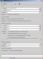
GUI Screenshot
The GUI
This is the default GUI
This is what the GUI looks like when running this program with
default parameters
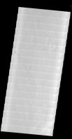
Input Image
Raw Data
Raw Input Data
This is the raw input data
Output Image
Final Output
The projected image (final output)
This is the output from this program. It was cleaned up and
projected.